Master Planning for the conservation of Rohtas Fort as per international standards has been made
possible by the co-operation and very valuable advice of all those who are involved in the
preservation and maintenance of this prestigious monument. The sheer number of these
individuals and specialist organizations who have contributed in one way or the other is
extensive. It is not possible to mention each one of them by name. M/s UNICON Consulting
Services (Pvt.) Limited thanks all of them for their unfathomable co-operation, help and support.
Unicom Consulting Services however, feels that the contributions made by some of them were of
a magnitude where it would be unjust and unfair not to mention them by name. One such
individual is Mr. Saleem- ul-Haq, Director, Northern Circle, and Department of Archaeology &
Museums (DOAM) who took keen interest and made untiring efforts in arranging meetings with
the custodians Rohtas Fort and providing access to information & data at the DOAM. His office
also contributed in a significant manner by providing related information and other valuable
assistance.
The Consultants are also indebted to Mr. Maqsood A Malik, Department of Archaeology
& Museums, (DOAM) Lahore Fort who took exemplary interest in arranging meetings with the
Rohtas Fort site staff to arrive at a consensus for preparation of Master Plan based on his earlier
experience for Conservation Works at Rohtas.
We also thank Mr. Tanvir Ahmad, Engineer (DOAM) for providing technical assistance after a
comprehensive analysis of existing environmental conditions at Rohtas.
Thanks are also due to the architectural staff of DOAM, Northern Circle Photographer
Mr. Amjad, the librarian at the Shahi Qila library and other assistants who were instrumental in
identifying old pictures, documents and other relevant data.
Thanks are also due to UNICON team who worked tirelessly and endlessly in collection of data
from the Rohtas Fort, DOAM, HWF, Documentation Office UNESCO Norad
Project Lahore, and its further analysis in the Head office and subsequent development of the
Master Plan and conservation works of Rohtas Fort.
The Unicon Team has benefited tremendously through the experience of its team member who
worked with the team on the Master Plan of the Shahi Qila Lahore and Conservation and
Management Plan of Shalimar Gardens, supported by UNESCO Norad, between
2003- 2005. The two documents have been the source of the methodology used for the
Master Plan of the Rohtas fort
Thanks are also extended to all officers and staff of HWF at Rohtas Fort. Our very special
gratitude to Dr. Anis ur Rehman and Mr. Vaqar Zakriya of HWF for their very value cooperation
and input which has enabled UNICON to prepare this document.
At the end the UNICON team would like to thank Mr. Shahid Rana who typed and compiled this
report.
Executive Summary
ROHTAS FORT MASTER PLAN
Executive Summary
The Rohtas Fort Master Plan provides a detailed and complete framework for
determining and implementing a coherent set of appropriate actions to preserve and
manage this World Heritage site. The aim of the Master Plan is to ensure that the cultural
heritage significance of Rohtas Fort is not compromised, and that the values for which
the monument was listed are not lost. It is intended to serve primarily as a working
document for those working on conservation efforts on the Fort. It also informs all levels
of government and concerned departments of their roles and responsibilities, as well as
providing a format for increased community and voluntary involvement in caring for the
site.
The report is divided into nine sections beginning with the first three identifying the need
& role of the Master document, its significance being a World Heritage Site followed by
a theoretical framework under which the UNICON Team has prepared the Master Plan.
The setting of the site is explained in the Historical Background and its condition as we
see it today. A detail visual conditio n survey was undertaken and has been presented as a
separate volume to the Master Plan Document. Based on the condition survey, the current
context and issues are discussed specifically under five headings.
- Conservation Issues.
- Management Issues.
- Monitoring & Maintenance issues.
- Environment & Physical Infrastructure issues.
- Visitation issues.
Section 6 of the Master takes into consideration all the issues discussed in the previous
section and presents a series of strategies to remove the obstacles and arrive at an action
oriented Master Plan.
Section 7 presents a series of actions designed to achieve the short and long term vision.
The action plan is based on the correlation between the issues and strategies elaborated in
the earlier two sections. The action plan is presented in the form tables keeping in view
the priority of the action, the resources needed and the agents involved the
implementation.
A separate conservation priority listing on the basis of Priority 1 (Emergency) Priority 2
stabilization, Priority 3 (Preventative Conservation) and Priority 4 (Conservation) for
each portion of the Fortification Wall, the Gates, and structures is provided. This list will
enable the allocation of funding by the implementers of the conservation works at Rohtas
Fort.
Implementation Mechanisms outline the term of the Master Plan, the process of
implementation, the agents responsible and a format for review of the Master Plan. A set
of Performance indicators is provided to review and measure progress in the longer term.
The final section 9 provides a list of recommendation for further specialist studies that
need to be undertaken within the term of the Master Plan to ensure preservation of this
World Heritage Site, maintain its cultural significance & values for future generations.
CONTENTS
ACKNOWLEDGEMENT
EXECUTIVE SUMMARY - INTRODUCTION TO THE MASTER PLAN. 1
1.1 Need and Role of the Master Plan 2 - WORLD HERITAGE INSCRIPTION. 4
2.1 Brief Background 5
2.2 Legal and Regulatory Framework 6 - THEORETICAL FRAMEWORK & VISION. 7
3.1 Vision of the Master Plan. 8
3.2 Standards for Intervention 9
3.3 Prioritization of Conservation Intervention 10
4.0 HISTORICAL BACKGROUND AND EXISTING SITUATION. 12
4.1 Location And Brief History 13
4.2 Description 13
4.3 Rohtas Town 14
4.4 Environment And Surrounding Areas of Rohtas Fort 16
4.5 Condition Survey 16
4.6 Drainage 41
4.7 Conservation Works 48
4.8 Geological Conditions 49 - ISSUES. 51
5.1 Conservation Issues 52
5.2 Site Management Issues 57
5.3 Monitoring And Maintenance Issues 64
5.4 Environmental & Physical Infrastructure Issues 66
5.5 Site Visitation. 76 - STRATEGY. 80
6.1 Conservation Strategy 81
Site Management Strategy 89
6.3 Monitoring And Maintenance Systems 103
6.4 Environmental And Physical Infrastructure Strategies 108
6.5 Visitation Strategy
ACTION PLAN. 120
7.1 Introduction 121
7.2 Correlation Between Issue And Proposed Strategy 122
7.3 Action Plan – Priority Works. 125
7.4 Action Plan Table. 125
7.5 Conservation Priority Works. 134 - IMPLEMENTATION MECHANISMS 137
8.1 Goals 138
8.2 Reviewing the Master Plan 141
8.3 Performance Indicators for Reviewing
Implementation of the Master Plan. 145 - RECOMMENDATION FOR FURTHER SPECIALIST STUDIES. 149
- REFERENCES.
LIST OF TABLES.
Table 5.1 Conservation Issues. 56
Table 5.2 Management Issues. 63
Table 5.3 Monitoring & Maintenance Issues. 65
Table 5.4 Environmental & Physical Infrastructure Issues. 75
Table 5.5 Site Visitation Issues. 79
Table 6.1 Summary of the Documentation System. 87
Table 7.2 Correlation Between Issues & Proposed Strategies. 123
Table 7.3 Action Plan Conservation Strategy. 127
Table 7.4 Action Plan Site Management Strategy. 128
Table 7.5 Action Plan Monitoring And Maintenance Systems Strategy. 129
Table 7.6 Action Plan Environment And Physical Infrastructure Strategy. 130
Table 7.7 Action Plan Visitation Strategy. 132
Table 7.8 Summary of Cost For Action Plan 133
Table 7.9 Conservation Priority List. 135
Table 8.1 Proposed Preliminary Performance Indicators. 145
LIST OF MAPS:
Map 1. Plan Between Sohail Gate & Sar Gate
Plan Between Sar Gate & Tulla Mori 23
Map 3. Plan between Tulla Mori & Wall Towards Gatayli Gate 24
Map 4. Plan between Gatayli gate & Khawas Khani Gate 25
Map 5. Plan between Khawas Khani & Kashmiri Gate. 26
Map 6. Plan Between Khawas Khani Gate & Talaqi Gate 27
Map 7. Plan Between Talaqi Gate, Langer Khani Gate & Shishi Gate 28
Map 8. Plan Between Shishi Gate, Kabuli Gate, Badshahi
Gate & Shahi Mosque 29
Map 9. Plan Between Badshahi Gate, Shahi Mosque & Phansi Ghat 30
Map 10. Plan Between Phansi Ghat & Sohail Gate 31
Map 11. Plan Between Shah Chandwali Gate & Dividing Wall 32
Map 12. Plan of Dividing Wall. 33
Map 13. Existing Drainage Conditions. 45
Map 14. Topographic Survey Plan of Rohtas Fort. 54
Map 15. Survey Plan of Rohtas Town. 68
Map 16. Site Visitation Routes. 119
LIST OF FIGURES.
Fig. 1.0 Schematic Diagram of Structure & Contents of the Master Plan. 3
Fig. 6.1 Diagram Illustrating Conservation Action Priority. 83
Fig. 6.2 Diagram Illustrating Proposed Flow of Conservation Action. 85
Fig. 6.3 Diagram of Proposed Management Structure. 95
Fig. 6.4 Diagram of The Proposed Diversified Funding Approach. 98
Fig. 6.5 Diagram Showing Monitoring Needs. 106
Fig. 8.1 Partner for Implementation of the Master Plan. 140
Fig. 8.2 Proposed Review Program 144
ANNEXURE:
Standardized Formats for Documentation of The Shahi Qila
Project.
ACRONYMS
DOAM: Department of Archaeology & Museum.
NFCH: National Fund for Cultural Heritage.
UNESCO: United Nation Educational, Scientific & Cultural Organization.
ICOMOS: International Council on Monuments & Site.
ICCROM: International Centre for Study of the Preservation of Cultural Property.
MGWCHS: Management Guidelines for World Cultural Heritage Sites, Fieldin,
Bernard and Jukka, Jokilehto, ICCROM Rome 1993.
SOP: Standard Operating Procedure.
PTDC: Pakistan Tourism Development Corporation.
TDCP: Tourism Development Corporation of Punjab.
SECTION – 1
INTRODUCTION TO THE MASTER PLAN
MASTER PLAN FOR
ROHTAS FORT
1.1 Need and role of the Master Plan
The Rohtas Fort is one of the six monuments of Pakistan inscribed on the
World Heritage list in 1997. However, as per requirements of the UNESCO
List of World Heritage sites the custodians of this location, namely the
Department of Archaeology and Museums (DOAM), Government of
Pakistan (GOP) have not been able to undertake appropriate maintenance,
conservation or up-gradation befitting of such a monument. “A management
committee” was established in 1996 and despite concerted efforts, lack of
funding for the conservation and maintenance of works did not allow
effective implementation to proceed. In 1999, the Governor of Punjab
emphasized the preparation of a Master Plan by DOAM, however, this did
not materialize again due to lack of funding. DOAM continued to prepare
various schemes based on P-C1 formats, which were also not implemented. It
was in 2005 that the Ministry of Culture requested DOAM to prepare a PC-1
incorporating all the funding requests of the previous PC-I, calling it a
master plan and approved a budget of Rs.163 Million for a period of five
years
In the year 2000 Himalayan Wildlife Foundation (HWF), a non-government
organization approached the National Heritage Fund for Cultural Heritage with a
proposal to conserve the Shah Chand Wali Gate. Since then they have been
involved in a number of conservation and development works within the Rohtas
Fort. These works, however have been piecemeal efforts and without any an
overall strategy or prioritization.
Realizing this the HWF initiated the development of a comprehensive Master
Plan and Unicon Consulting Services (Pvt) Ltd were requested to undertake this
task based on a technical proposal submitted by UNICON to HWF.
The objective of the Master Plan is to prepare a document that will provide a
detailed and holistic framework for decision-making as well as a set of
appropriate actions for conservation and management of this World Heritage Site.
The specific objectives of this document are.
An assessment of the existing physical condition and the immediate
environs.
To prioritize conservation action including identification of immediate and
emergency actions, keeping principals of conservation & preservation
charters in view.
To suggest an effective management monitoring and maintenance system.
To present a tourism management and visitation program to enhance
visitor experience.
To upgrade the physical environment & infrastructure.
A comprehensive Master Plan is required to ensure the preservation of this
monument, maintain its cultural significance and provide its visitors an
experience that will educate them and enhance their knowledge, ensuring that the
cultural values for which the monument was listed as a World Heritage site is not
compromised or lost.
SECTION – 2
WORLD HERITAGE INSCRIPTION
WORLD HERITAGE INSCRIPTION:
2.1 Brief Background
Rohtas Fort was inscribed on the World Heritage list in 1997. To be included in the
World Heritage List sites must be of outstanding universal va lue and meet at least one out
of ten selection criteria. It was inscribed on the basis of the selection criteria (ii) and (iv)
considering that that Rohtas Fort is an exceptional example of Muslim military
architecture of central and south Asia which blends architectural and artistic traditions
from Turkey and the Indian sub continent to create the model for Mughal architecture and
its subsequent refinements and adaptations. The selection criteria (ii) and (iv) read as
follows:
(ii) To exhibit an important interchange of human values, over a span of time or
within a cultural area of the world, on developments in architecture or
technology, monumental arts, town-planning or landscape design;
(iv) To be an outstanding example of a traditional human settlement, land-use, or seause
which is representative of a culture (or cultures), or human interaction with
the environment especially when it has become vulnerable under the impact of
irreversible change;”
The World Heritage inscription is an internationally recognized designation, which
encourages national governments and site managers to ensure long -term protection
of sites of global significance
Statement of cultural significance
The “Burra Charter” states that the aim of conservation is to retain the cultural
significance of a place (Article 2.1) and that places of cultural significance should be
safeguarded and not put at risk or left in a vulnerable state (Article 2.3). It is the
responsibility of the state parties “to maintain the authenticity, and in the case of
World Heritage Sites, the cultural values for which the site was inscribed”
(Management Guidelines for World Cultural Heritage Sites (MGWCHS)).
The objective of the Master Plan for the Rohtas Fort should focus on protection and
maintenance of the physical features of the fort as well as to conserve the overall
environment and settings of the site. All conservation treatment should incorporate
detailed documentation of the original features, the interventions made and all
conservation techniques should focus on a guaranteed protection of the authenticity of the
site within the legal and regulatory framework.
Legal and Regulatory Framework
Rohtas Fort is a protected monument under the Federal Antiquities Act (1975)
(Act VII of 1976). The act stipulates the following points, relevant to the World
Heritage site:
The Federal Government will constitute an Advisory Committee (Clause
3) for the Conservation of a World Heritage Site.
The Federal Government may, by notification in the Official Gazette,
declare any antiquity to be a protected antiquity (Clause 10 (1)). There is
also a requirement to fix a notification in a “conspicuous place or near the
antiquity” for the information of the general public.
The Act is clear regarding the use that the protected monument or site may
be put to. Clause 18 states that “A protected immovable antiquity shall not
be used for any purpose inconsistent with its character or for a purpose
other than that directly related to its administration and preservation.”
Clause 19 clearly stipulates the fine and punishment in case the ‘antiquity’
is damaged or destroyed: “ No person shall, except for carrying out the
purposes of this Act, destroy, break, damage, alter, injure, deface or
mutilate or scribble, write or engage in any inscription or sign on, any
antiquity or take manure from any protected antiquity”. Infringement is
punishable (19(2)) “with rigorous imprisonment for a term which may
extend to three years, or with fine or with both.”
Clause 22 requires that “no development plan or scheme or new
construction on, or within a distance of two hundred feet of a protected
immovable antiquity shall be undertaken or executed except with the
approval of the Director General.”
Clause 23 (i) prohibits placing of “any neon signs or other kinds of
advertisement, including bill posting, commercial signs, poles or pylons,
electricity or telephone cables and television aerials, on or near any
protected immovable antiquity.”
SECTION – 3
THEORETICAL FRAMEWORK &VISION.
THEORETICAL FRAMEWORK.
3.1 Vision of the Master Plan.
The Vision and Principals on which the Master Plan document has been
approached theoretically is outlined below. This vision has to a large
extent been drawn from the principles stated in various international
charters and also that adopted in the Master Plan document for the Shahi
Qila and the Shalimar Gardens, Lahore
3.1.1. Maintaining the authenticity of the site.
The single most important aim of conservation is to retain the cultural
significance or authenticity of a place, the aesthetic, historic, scientific, social or
spiritual value for past, present or future generations. Given that values can change in
nature and perception, the assessment of values should be reviewed at stages, listing
further values and broadening the focus for protection of all significant values.
3.1.2. Safeguarding all original remnants as a priority.
All interventions should be reversible and based on a strategy of minimum
intervention. The original elements to be safeguarded include those accrued with the
passage of time and changes in historical circumstances. These accumulated changes
have themselves become part of the historical character and material substance of the
site. “This material substance represents the intrinsic values of the cultural resource; it
is the bearer of historical testimonies and of associated cultural values, both past and
present (MGWCHS)”.
The importance of retaining original fabric and its inherent values was recognized
by John Marshall, whose Conservation Manual written in 1923 has served as the
main reference for DOAM:
“Although there are many ancient buildings whose state of repair suggests at first
sight a renewal, it should never be forgotten that their historical value is gone
when their authenticity is destroyed, and that our first duty is not to renew them
but to preserve them. Broken or half decayed original work is of infinitely more
value than the smartest and most perfect new work”. (Marshal 1923: 9-10)
3.1.3. All decision making based on full documentation and research.
The Master Plan has taken the following statements from the “Draft Hoi An
Protocols” to reflect the pivotal importance of research and detailed documentation
for the conservation process:
conservation plan should only be taken after extensive research, expert discussion
and weighing of conservation options. Intervention should be the minimum
required to ensure the preservation of the heritage values and the authenticity of a
monument or building”.
3.1.4. Conservation & Management Planning must be Sustainable.
All programs and action plans addressing the protection and maintenance of Rohtas Fort must be sustainable. This means
that decisions are made on the basis of up to date, reliable and usable information and that all actions are at best reversible,
or at least the minimal needed, “changing as much as necessary but as little as possible” (Burra Charter) and fully
documented. Programming should be designed in such a way that it can continue along clearly defined paths, following
well designed and focused methodologies, regardless of changes in staffing or administration at the site.
3.1.5. Tourism should support conservation and conservation should meet Tourism
Needs.
All tourism efforts should include adequate controls to prevent the intrusive and
destructive impacts of tourism. Tourism activity should not undermine the
authenticity and integrity of the historic structure. All earnings from tourism
should be directed towards maintenance of the cultural assets and the
communities on which tourism is based.
3.2 Standards for Intervention
The reason for selecting one level of intervention over others depends upon a
number of factors, including the nature and heritage value of the building or site,
the goals of the conservation project, the scale of the resource being conserved
and the financial and human resources available.
Most heritage conservation projects, by necessity, involve a combination of
approaches rather than isolated interventions. Within a project that seeks to return
a building to an earlier appearance (restoration’), it may be necessary to reinforce historic structural elements (consolidation), upgrade entrances / exits, and services (rehabilitation’), and perhaps to dismantle a section in order to replace intrusive
elements and to support historic portions (`reassembly’).
The most critical stage in the conservation process is deciding which one or more
approaches to adopt. This decision determines the extent to which the integrity of
the historic fabric is retained. The preferred levels of intervention are always
those which show full respect for historic fabric, maintaining and supporting
existing fabric with a minimum of modern addition. Actions falling into the
second level of intervention, those which exhibit only moderate respect for
original material, should only be employed in rare situations and with detailed
justification. Actions showing little respect for historical fabric should be avoided
whatever the circumstances.
Efforts must be made to ensure the following:
That an assessment of appropriate level(s) of conservation be
carried out in advance of any conservation decision making;
The assessment should be based on authentic information and full
documentation;
International standards and guidelines for conservation must be
followed.
All decisions should include reference to these standards and
should be made after full discussion between the custodians of the
site, the Project Management Team and the Technical Committee.
All decisions should be made available for public comment and
debate.
3.3 Prioritization of Conservation
Interventions
There is a need for setting of priorities for conservation action in order to ensure
efficient and effective investment of time and money. Work should be carried out
on the basis of need as assessed by analysis of the severity of the conservation
situation. As stated in the Management Guidelines for World Cultural Heritage
Sites (MGWCHS), “the inevitable contradictions of the planning process should
be resolved first by examining the implications of all viable alternatives, and then
by deciding which is least harmful to the significance of the heritage site”.
Severity can be assessed as the relative relationship between inherent
significance in relation to current physical condition and the nature and
extent of threats. The data needed to carry out this measurement includes
statement of significance for individual built elements, regular monitoring
reports and expert assessment.
3.3.1 Conservation Situations
Conservation Situations can be categorized as:
a. Critical and in need of Emergency and / or Stabilization Action:
Element(s) of high cultural significance in poor condition which are
rapidly worsening and there is an imminent danger of loss of those
qualities / features which are the basis of significance. Immediate action is
required which will substantially improve the situation in both
environmental and conservation terms.
Serious and in need of Preventive Conservation.
Elements of high or medium cultural significance in poor condition which
are progressively worsening and there is growing danger of damage to or
loss of those qualities/ features which are the basis of significance. The
problem is serious and may have existed for a long time; however, shortterm
action begun within the next six months to a year and completed
promptly will significantly improve the situation.
c. Ongoing and in need of Conservation Action:
Elements of high or medium cultural significance which are in poor
condition and relatively stable, although there is a danger that they may
eventually result in damage to or loss of those qualities / features which
are the basis of significance. Longer term action in the form of studies
may be needed and should be started as soon as possible; however, the
whole process may require a longer time scale before improvement can be
seen.
3.3.2 The Aim of Prioritization
The aim of prioritization is three fold:
To identify the significant elements of each structure and also
buildings as a whole which are in “Critical Condition” and require
emergency action;
To identify “Serious Situations” which are progressively
deteriorating and require preventive conservation action in the
short term;
To identify “Ongoing Situations” in need of study and/or longer
term conservation planning.
SECTION – 4
HISTORICAL BACKGROUND AND
EXISTING SITUATION.
CONDITION SURVEY.
HISTORICAL BACKGROUND AND EXISTING SITUATION
4.1 LOCATION AND BRIEF HISTORY
The fort of Sher Shah Suri at Rohtas is situated in 32o 55N and 73o 48 E, 16
kilometers north-west of Jhelum town, in the gorge where the Kahan torrent
breaks through the low eastern spur of the Tilla Range. The gigantic stronghold,
which is emblematic of Sher Shah Suri’s vigorous rule, is strategically positioned
as it commands the old route from north to the plains of the Punjab. Its
construction was initiated on the orders of Sher Shah Suri in 1541 and completed
in 1543 AD. The main purpose for the construction of this Fort was to block the
possible return of the Mughal Emperor Humayun who after the defeat at Chaunsa
by Sher Shah Suri, had fled to Iran. His second object was to give a severe blow
to the old friends of the Mughal who would have gladly helped Humayun to
capture his lost empire. A number of historic visits by Mughal Emperors Akbar
and Jahangir have been recorded. Ranjit Singh has also camped on one of his
unsuccessful expeditions of Kashmir.
4.2 DESCRIPTION
Today the fort is approached from Dina on the National Highway by a narrow 12
feet wide tarmac road. The most spectacular and majestic part of the fort is the
fortification wall, which is irregular in plan and covers over a 4 kilometer
perimeter. It contains sixty-eight bastions and twelve named gateways. An
additional four smaller openings are also seen in the fortification wall, which may
have acted as gates, or as storm water drainage cha nnels. The massive stonewalls
are 30’ to 40’ thick at the base and 30’ to 60’ high. The alignment of the
fortification has been controlled by the difficult contour of the hillock on which it
has been constructed. It is everywhere pierced for musketry or archery, and here
and there for cannon: in the parapets near the gateways are machicolations, from
which molten lead or hot water could be poured on attacking troops. A number of
galleries are provided in the thickness of the wall for soldiers and storage. The
wall is usually composed of two or three terraces, which are linked by staircases.
The interior of the fort is divided by a cross-wall which is approximately 577
yards long most of which is damaged and fallen today. This wall segregates the
citadel/royal area from the general area reserved for the army. It is in accordance
with the tradition of ancient time of having a citadel for the chieftains. Though
devised for purely military purposes, some of its gates are exceptionally fine
examples of the architecture of the period.
There are a number of standing smaller structures within the citadel or the
“andarkot”.
a. Maan Singh’s Haveli (General of Emperor Akbar).
b. Rani’s Mahal
c. Shahi Mosque.
To meet the need of self-sufficiency in water three “baolis” were constructed
inside the Fort by cutting deep into the lime rock. One of these baoli’s lies near
the Kabuli Gate and the other adjacent to Langar Khani Gate. A very spectacular
“baoli” stands near the Pipalwala Gate. All the baoli’s are currently not in use
Two important Sikh monuments one the birthplace of Mata Kaur, is located
within the small town that has developed. Choa Guru Nanak, a Sikh Gurduwara
with an adjacent pond is located just outside the Talaqi Gate.
The entire area of the fort today is covered with overgrown vegetation and
shrubbery. It is quite likely that under the shrubbery there are massive
archeological remains of structures built for use by the army at the time of its use
as a fort. Within the fort the overall ambience is marred by the wild growth of
grass and Kekar, a thorny shrub. There are hardly any trees, which have probably
been cut by the residents of Rohtas town for use as fuel or construction. It is seen
in some old photographs that the residents of Rohtas town used the Citadel areas
for cultivation. This was probably another cause of cutting down of trees.
4.3 ROHTAS TOWN
A small town (population 3000) has developed between Khaws Khani Gate and
Sohail Gate and it is continuously expanding due to lack of control by the
custodians of the site. The residents claim that they have been living here for the
last three to four hundred years however there is no record to support ownership
of the land. There is a school building constructed by the British in 1926. The
plaque ind icates that the school was operating in a residence since 1856 indicating
that there must have been a settlement at the time. Today there are two separate
primary schools and two High Schools for boys and girls run by the education
department. There is a block of buildings, which were used as hostel for the
school however today it stands vacant. The High School for girls has recently
extended its boundaries to cover twice its land area indicating that even the public
sector agencies have little respect of our World Heritage Site. There is an old
Hindu temple south east of the town. It is lying in a derelict state with no
maintenance and the local community does not have any association with it.
There are sixteen (16) mosques belonging to the Shia and Sunni Sects as well as
three (3) Imambarghas. The birthplace of Mata Kaur is a small Sikh period
structure however the adjacent resident has constructed a toilet with its roof
supported on the wall of the shrine, a revered place of the Sikhs. A large number
of graveyards are dispersed within the walls of the fort. The location of the graves
in the south and east of the town is an indication of the limits of the residential
area of the past. Today, the graves are surrounded by housing, in the south,
indicating the fact that these are new developments.
The unplanned settlement continues to grow without any checks. There are some
houses whose walls are constructed of stone and lime mortar indicating there age
to the previous century or the earlier part of the2oth century. Some of the older
houses have been constructed with burnt bricks laid in mud mortar. The roofs
have wooden beams and battens with mud padding at top for insulation. These are
dispersed within the town, and should be preserved. The community however is
unaware of the concept of heritage preservation. In the recent constructions,
bricks have been laid in cement sand mortar for walls and the roofs have steel
girders and T-iron battens. Tiles have been laid on roofs and plastered for
providing good drainage. The latest addition is that of RCC Roofs.
Till late all the streets were unpaved and without designed slopes. There was no
sewerage system and people were going out to the fields for the call of nature.
In 1997 the fort was inscribed on the World Heritage list and after that some
attention has been paid to the development of the village. HWF has played a
pivotal role in the development activity of the town. Community organizations
have been formed and infrastructure in terms of water supply and sewerage
systems are being provided. A ten thousand gallons overhead water reservoir has
been constructed in the center of the village for supply of drinking water to the
entire village by gravity system. This overhead water reservoir is linked to a
Turbine by 3” diameter galvanized iron pipeline. The pump house is located next
to the Choa Guru Nanak Shrine in front of the Talaqi Gate.
Part of the village has been provided proper sewerage system, which is linked to
sludge ponds for disposal of sewage. This is an environment friendly system and
is capable of providing manure to the villagers for agriculture purposes.
The main street of the village on which most of the shops are located has been
paved with concrete pavers with the support of HWF. This street has been named
as Heritage Street. From the study of the Rohtas Town plan as well as information
gathered from the residents it appears this was the main route linking Khwas
Khani Gate to Sohail Gate. The current tarmac road indicates the new
developments and encroachments that have taken place in the recent past. A few
more streets have been brick lined with drains on either side for the drainage of
sillage water and the storm water.
Most of the streets are still dusty and uneven. The villagers by and large are used
to living under primitive conditions and expect the government and the NGO’s to
provide all the modern day services at their doorstep. An outcome of provision of
services to the community has been consolidation and improvement of the
housing. The negative aspect has been increased encroachments on the land and
an increased pace of construction. This is in violation of the Antiquities Act
however the Department of Archaeology has been unable to stop this due to lack
of staff and magisterial powers. The political leadership of the area has its own
vested interests and will allow the residents to expand their housing on land that
belongs to the state and is protected under the Antiquities Act.
ENVIRONMENT AND SURROUNDING AREAS OF ROHTAS FORT
Rohtas Fort is located approximately 7 kilometers off the National Highway/GT
Road from Dina. The environment along the road leading from Dina to Rohtas
comprises partially agricultural land with scattered hamlets. The improvement of
this tarmac road and the construction of Sher Shah Suri Bridge over the Kahan
River have resulted in increased development along this road. The overall
geographical terrain of this area is undulating with deep ravines and riverine
deposits of conglomerate stone, pebbles and alluvium. The area between Jhelum,
Rohtas and Tilla Joggian of an approximately 10 kilometer radius is historically
very rich dating back to the conquests of Alexander of the region. Some of the
hamlets in this area have old historic structures dating back over one hundred
years.
4.5 CONDITION SURVEY
The Unicon team has undertaken a visual survey of the overall site recently. It has
also collected some data in terms of old photographs from the Department of
Archaeology, Northern Circle (DOAM) and a comparison of the condition of the
buildings at the time of the previous photography and the present condition has
been collated. This information is provided in detail in the volume “Condition
Survey of Rohtas fort” as Annexure 1.
The condition survey undertaken by the Unicon team assisted by the staff of HWF
and the Department of Archaeology indicated three primary aspects that are
affecting the overall condition of the Rohtas Fort these are:
I. Storm Drainage and water percolation in the structures and open areas
II. Wild growth and low maintenance
III. Impact of the development of the Rohtas town
A critical concern of the Rohtas Fort is the condition of the fortification wall,
which is the most spectacular and majestic part of the fort with its 68 bastions and
12 gates covering a perimeter of 4 kilometers. The drainage patterns, soil
conditions and the geological strata of the land are the primary causes of the
sliding of the wall and bastions. The condition of structures has also aggravated
due to lack of maintenance. Crevices in the terraces of the wall allow water to
percolate into the wall structure causing additional damage. There has been a
change in the overall topography of the inside of the fort due to the change in the
land use. There is evidence showing extensive use of the land for agricultural
purposes till the 1990’s for over two centuries. Terracing and reshaping of the
topography by landfill of sweet earth has caused a change in the original drainage
pattern that was designed for the fort. Agriculture farming demanded retention of
the water for the crops and the storm drainage holes in the walls, if not blocked
due to the raised fields were intentionally closed. This caused water percolation in
the subsoil causing settlement of the loose rubble infill between the stone and
lime mortar walls. The walkways and terraces along walls have settled
developing holes and large fissures. This damage is further compounded by
rainwater that found its way into the walls causing bulging, tilting and collapsing
of the structural walls due to the percolation of large amounts of water. The
movement of the walls developed further cracks and damage to the adjacent
structures further compounding the damage. At places the impact of the storm
drainage has been total scouring of the external slopes resulting in collapse of
large portions of Fort Wall. These collapsed walls create their own set of
problems, in terms of the originally designed or natural storm water routes that are
redefined.
The Kahan River has had its impact on the walls of the fort during flooding over
the years. The turbulent waters during flooding have impacted the walls
particularly along the west at Kabuli Gate and the area between Shishi Gate and
Shahi Gate resulting in the failure of large portions of the wall.
The growth of the settlement is also causing damage. There are large areas
covered with graves some old dating back to the 19th century whilst most of them
are new and built in the 20th century primarily by the residents of Rohtas town.
The lack of any built structures within the fort indicates their possible destruction
by the residents. There has been no archaeological excavation in the site to
indicate the way the fort was used. The area where the current settlement is
located is also possibly on an old archeological site, considering it is on a route
that links the two accessible gates –Khwas Khani and Sohail gate. The presence
of the birth Place of Mata Kaur and an Old Hindu Temple are also indications of
the age of the settlement, which has possibly grown on an older settlement. The
rearing of animals, their grazing, cutting of trees have all added to the
deterioration of the structures of the fort.
The brief condition of the various structures is provided below. The structures
comprise:
a. The External Fortification Wall, its terraces and built-in rooms
b. Cross wall separating the “Andarkort”(Citadel) area from the town area
c. The 68 Bastions
d. Gates
e. Shahi Masjid
f. Maan Singh’s Haveli
g. Rani’s Mahal
h. Three Baolis
i. Sikh Monuments Choa Guru Nanak and Janam Asthan Mata Kaur
j. Hindu Temple
THE EXTERNAL FORTIFICATION WALL
The Rohtas Fort perimeter wall is a masterpiece of civil engineering works. The
wall measures about 4 km in linear length. The wall is 30 to 40 feet wide at the
foundation and tapers upwards. The height varies from 30 to 60 feet depending upon
the location. As the Fort was constructed purely to meet the tactical requirements
therefore the wall has been constructed on a stone ridge with it’s foundation based on
the highest points of the ridge. The foundation is 3’ to 5’ deep depending on the depth
of firm footing.
The wall consists of three independent walls with a common footing. Each wall
has been constructed with stones laid in lime mortar. The outer wall has a smooth
outer surface with marlons at the top for the use of archers and musketeers. The
second highest is the middle wall and the third wall is the inner most wall. This
wall has the stairs cases, which lead up to the terrace adjacent to the marlons. An
examination of the cross section of the wall shows two terraces, one at the top for
the Archers and the second about 10’ below probably for the 2nd line of soldiers
who were to replace the wounded or tired men positioned at the top.
The space between the three walls has been filled with random rubble masonry
laid in mud mortar. The wall has built in rooms with arched roof at strategic
locations for the housing of soldiers and foodstuff. The terraces created into the
infill along the walls have developed cracks and water percolation is damaging
the walls & settlement of the terraces in seen.
In addition to the marlons, machilons have also been provided with the main
Gates i.e. Khawas Khani Gate, Sohail Gate, Gatali Gate and the Talaqi Gate for
pouring of molten lead and hot oil / water on the enemy soldiers approaching the
wall / gates for demolition purposes. The outer face of the wall is very smooth and
is unclimable even by the most experienced climbers.
However today large portions of the wall are scouring particularly in the areas
where the storm drainage is directed out of the fort. The contours of the internal
areas of the fort provide the main cause of the external scouring.
Wall between Shishi and Shahi Gate
Major portion of the perimeter wall between Shishi Gate and Shahi Gate has
collapsed due to erosion of foundation by the Kahan river and the effects of rain
and the free flowing storm water. Sketch showing the extent of damage is
attached as Annexure A’. During the condition survey of the structure it has been noted that the structure has suffered due to improper drainage. The mortar from the joints has fallen, resulting in displacement and loss of stones. The top of the walls and the structure has developed serious cracks and rainwater is penetrating in the structure. The top surface of the whole structure needs water proofing with the original mortar to control the penetration. The wild growth is also playing major role in the deterioration of the structure. This should be removed very carefully. To stop the erosion at the base of the structures, the underpinning work of the structure with the original materials and the diversion of water away from the Fort structure be planned on priority basis. Wall on either side of Phansi Ghat The foundation of wall is eroding on both sides of Phansi Ghat due to change in drainage pattern. This is due to the raising of the internal level with soil that has eroded as well as the deposition of the fallen structures of Maan Singh Haveli and filling of sweet earth along the inner wall for cultivation purposes. There is a raise of almost 25 feet in one part of the inner section of the fort from the original level. This has resulted in the blockage of the storm water channels meant for draining of rainwater out of the fort area which is having an adverse impact on the fortification wall Wall between Tulla Mori and Gatali Gate Damage is also visible along the eastern wall between Tulla Mori gate and Gatayli gate specifically in the areas where the natural landscape forms the storm water channels. Major portion of wall adjacent to the play ground on the south of Gatali Gate has given away / collapsed due to erosion of foundation by the storm waters and blowing of earth from the foundation by strong winds. Sketch showing the damaged portion is attached as AnnexureB’.
Wall between Gatayali and Khawas Khani Gate
Several portions between the gates have fallen down due to ingress of rainwater
from the top and erosion from the bottom. The wall is also affected due to the lack
of maintenance, growth of wild bushes and grass along and on the wall with the
roots deep into the joints, contributing to cracking of walls and displacement of
stones, all helping in the deterioration process. Sketch showing the damaged
portion is attached as Annex `C’.
Wall between Mori Gate and Talaqi Gate
The wall between Mori and Talaqi gate has collapsed at several places due to
penetration of rainwater from the top of the wall and erosion of the foundation
due to storm water.
The drainage pattern of the area has been disturbed due to lack of maintenance
and creation of borrow pits by the inhabitants of the Rohtas Village. During the
recent site survey it was observed that long time back part of wall next to inner
wall separating the citadel from the rest of fort had collapsed and was not restored
for quite some time. This has resulted in erosion / washing away of soil, thus
lowering the bed levels and eroding the foundation of the external wall (Perimeter
wall). The damaged portion through stands restored but has disturbed the whole
drainage pattern. This speaks of lack of expertise in the conservation works and
should be avoided in future conservation / restoration sketch showing damaged
portion is attached as Annex “D”.
4.5.2 CROSS WALL SEPARATING THE “ANDARKORT”(CITADEL) AREA
FROM THE ROHTAS VILLAGE.
This wall has almost completely collapsed except few portions, which are in
precarious situation primarily due to the storm water channel running from Shah
Chand Wali Gate to the drainage point in the north wall. The storm water channel
has eroded the foundations resulting in the collapse of the wall. The impact of the
collapse of this wall is also seen on the structure of Shah Chand Wali Gate, which
is also showing cracks, and signs of stress. Wall between Shah Chand Wali gate
and Phansi Ghat is also now existent. The depression on both sides of this
accumulates storm water in the parking lot and the events area resulting in water
penetration into the foundations of the wall leading to its further deterioration.
4.5.3 BASTIONS
There are 68 bastions spread more or less evenly through the wall. Bastions have
been constructed at every turn or angle of the wall, which is essentially following
the topography of the rock strata. The sizes of the bastions vary from a diameter
10 to 70 feet, the largest flanking Sohail Gate. Damage to the bastions is visible in
a large number of them at the base where scouring has take place due to storm
water penetration at the foundation level. About fourteen bastions have almost
collapsed till to date and need major restoration works.
The bastion adjacent to Shahi Gate is scouring badly. Conservation works
undertaken by the British is damaged again and requires immediate attention
4.5.4 THE GATES
There are ten main gates, three smaller openings also named as gates and an
additional 4 small openings in the fortification wall which may have been used as
gates and were also possibly designed for storm water drainage.
“Maps Indicating
Damaged Portion of the
Fortification Wall”
PLAN BETWEEN
SOHAIL GATE & SAR GATE
PLAN BETWEEN
SAR GATE & TULLA MORI
PLAN BETWEEN
TULLA MORI & WALL TOWARDS GATAYLI GATE
PLAN BETWEEN
GATAYLI GATE & KHAWAS KHANI GATE
PLAN BETWEEN
KHAWAS KHANI GATE & KASHMIRI GATE
PLAN BETWEEN
KASHMIRI GATE & TALAQI GATE
PLAN BETWEEN
TALAQI GATE, LANGER KHANI GATE &
SHISHI GATE
PLAN BETWEEN
SHISHI GATE, KABULI GATE,
SHAHI GATE & SHAHI MOSQUE
PLAN BETWEEN
SHAHI GATE, SHAHI MOSQUE &
PHANSI GHAT
PLAN BETWEEN
PHANSI GHAT & SOHAIL GATE
PLAN BETWEEN
SHAH CHANDWALI GATE & DIVIDING WALL
PLAN OF DIVIDING WALL.
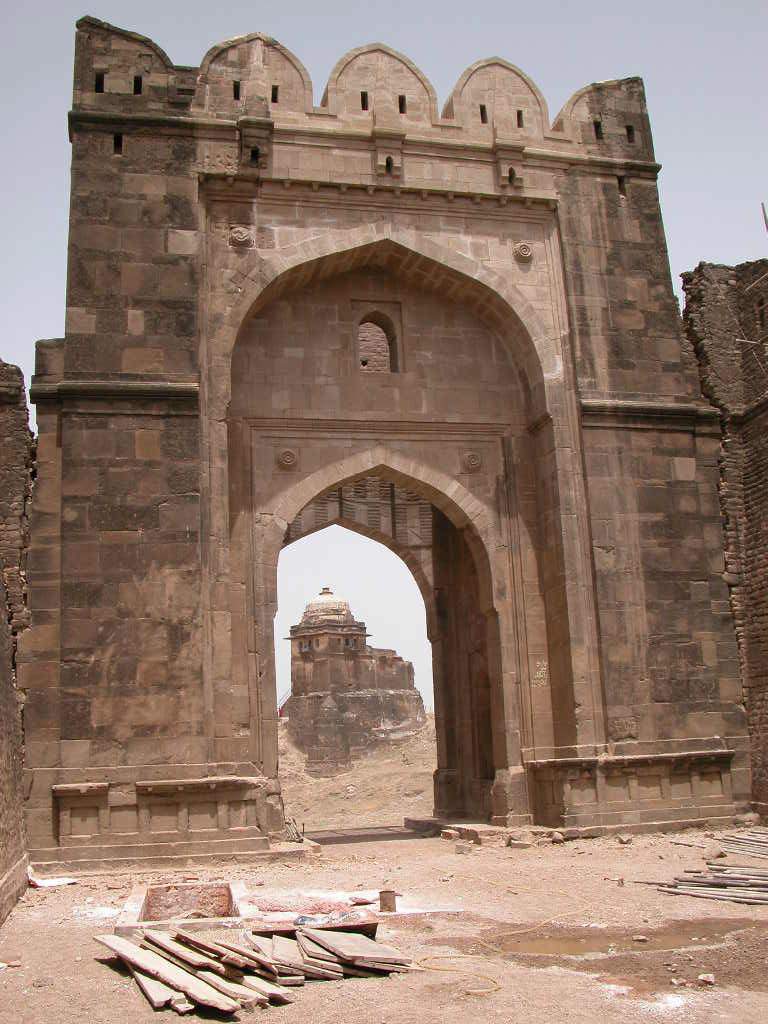
Shahi Gate
Some marlons between the Shahi Gate and “baoli” stand damaged from several
places. The recent earthquake has also affected the right side outer bastion of the
main Shahi gate. The foundation of the gate has also been displaced and cracks
are visible in the walls. DOAM did conservation works on this gate in the 1990 on
the same portion where British period intervention had also been done. The
external area of the gate has dilapidated view as the steps leading to Kabuli Gate
and the Baoli have disappeared and visitors have to cross this area through
overgrown vegetation and uneven ground. The masonry works at the base of the
bastions of the Gate has begun to scour and immediate attention is required to
stabilize the damage being caused by water penetration from the terraces of the
walls and the bastion roofs. The recent clearing of vegetation of the Baoli area
once again indicates the spectacular architecture and engineering practices of the
time. The clearing of the vegetation shows the damage that water percolation has
done to the walls resulting in bulging of the wall, cracks appearing which further
aggravate the situation due to further water percolation into the structure and
scouring of the external masonry.
Kabuli gate
The bastions and the walls between the Shahi gate and Kabuli gate have collapsed
possibly due to the flooding of the Kahan River. The gate stands precariously
balanced in a danger of complete collapse. The piling of mud against the inner
side of the Baoli results in percolation of storm water into the walls of the gate
causing additional damage. Just the removal of this earth will help protect the gate
from imminent collapse. Construction of retaining walls to provide stabilization to
the gate structure will also help in stabilization.
Shishi Gate
The Shishi Gate of the fort derives its name from the glazed titles having Persian
blue colour used in the spandrels of the outer bigger arch. These tiles, which are set
on the plaster base, “are the earliest example of this technique which later on
developed highly at Lahore”. An inscription on the Shishi Gate in Persian, gives the
date of the construction of the fort as 948 A.H. The inscription, carved on a marble
slab, measures 20” and 19.6” and is set on the left side of the gate. It reads:
Trans.
In the Hijri year 948 came the exalted—
At that time constructed the great fort—
The emperor is Sher (Shah) who gives stability to the world—
There is no match to his good fortune—
It was completed by Shahu Sultani.
A vertical full-length crack in the front wall of the Shishi gate has appeared.
There are fabulous chambers in the Bastions of the Shishi gate with calligraphy of
Quranic verses in stone carvings. These are being damaged due to dampness
penetration from the roof cracks and wild growth on the top. Shishi gate is the
most decorative of the gate and it demands immediate attention in terms of
emergency repairs and preventative conservation works.
Langar Khani Gate
This gate was probably the primary Royal entrance to the fort from the original
GT road constructed by Sher Shah Suri. A baoli and a number of
chambers/barracks are just inside the gate, which are in very poor condition due to
lake of maintenance and the wild growth. The baoli needs to be reactivated if
possible. A most spectacular ramp between the two fort walls from entrance gate
leads to the Shishi Gate. Currently the ramp is overgrown with wild growth,
which is also damaging the walls along the ramp.
The inner wall is also scouring at the base and it requires immediate attention.
The primary arch of the main gate has settled due to the sub soil movement. The
cracks are visible at the centre point. The mortar from the joints has come off and
the stones have been loosened / displaced from their original position. The area
outside the gate requires clearance and preventive conservation in terms of
construction of a series of retaining walls and ramps to lead up to the gate from
the level above the flood plain of Kahan River.
Shah Chand Wali Gate.
HWF has undertaken conservation of the gate, however, the restored portion of
the gate continues to develop cracks. The newly prepared stone marlons have
been displaced from their original place. The lower arch has also developed
cracks at several places. The stone masonry wall is also damaged due to failure of
the arch.. The possibility of storm water penetration from both the lower portions
on either side of the gate (Parking lot and events area) also demands a study. The
burj on the top of the gate is in a very precarious condition and scaffolding is
currently supporting it due to the continuous movement of the structure. A
detailed monitoring system needs to be put in place to understand the reasons for
this movement and preventive actions taken to protect this gate from any further
damage.
Sohail Gate
The Sohail Gate guarding the south – west wall is in fair condition. It is 70’ high
and “consists of a central archway placed within a larger arched recess, with an
oriel window projecting from the walls on either side. Every part of its structure
has been carried out in a broad and simple manner, each line and plan has a sober
and massive elegance, while the whole is a aesthetically competent.” The British
used the upper portion of this gate as a residence and some quarters and toilets
have been constructed on the roof terrace. The presence of a tomb/mazar in the
chambers at the ground floor is also causing damage to the structure due to the
burning of candles and fire by the caretaker of the tomb.
HWF has recently begun conservation and adaptive reuse of the spaces of the
gate. The first floor has been cleaned, the cement plaster on the walls removed
with the intent to use this space as a museum. The ground floor chambers have
been converted into a visitor’s information center. The roof of the top floor has
developed cracks due to ingress of rainwater and leaks during the rains. The wild
growth on the roof needs uprooting to safeguard against penetration of rainwater.
HWF is already in the process of conservation of this gate.
Gatayli Gate
The Gatayli gate is currently being restored by the HWF after failure of the
previous stabilization works, which were under taken by the Department of
Archaeology (DOAM). Several marlons between the Tulla Mori Gate baoli and
Gatayli gate are missing.
Khawas Khani Gate
The gate is well preserved and structurally in good condition. Due to lack of
maintenance few marlons have fallen down which need to be restored. Currently
it is the main entrance to the Rohtas fort and being adjacent to the town the walls
have a lot of graffiti and it is being misused. A tomb has been constructed in the
immediate entry to the gate and the boundary wall of the tomb enclosure juts out
into the main gate opening. A well in the entrance “deori” is filled with garbage
and earth and is not operational. Just outside the gate are a number of old tombs
possibly belonging to the Suri/Mughal period. The residents of the town throw
their garbage outside this gate presenting a very poor impression to the entrance
of the World Heritage site. The wall on the east of the entrance has been
considerably damaged due to the storm water channel.
Kashmiri Gate.
The gate is showing affects of poor maintenance. The mortar from the joints is
coming off, resulting in loss of strength, which needs immediate pointing with the
original mortar on priority basis. The floor of the gate has become uneven and
rainwater is penetrating in the structure. The floor needs to be re- laid properly
with adequate slopes for draining out the rainwater. Due to erosion the right outer
bastion has developed a cavity at the bottom of the bastion, which needs under
pinning to avoid any further damage. The water supply pipeline passing through
the gate is leaking and the water penetration is visible in the structure. The mortar
from the joints of the structure has also come off, resulting in the loosening of the
stones forming the structural members.
Talaqi Gate
This gate has recently been restored by HWF. However some cracks have
reappeared in the roof of the main gate and are being filled / treated.
The outer steps of the gate, which were reconstructed recently, are not according
to the original layout. This has resulted in poor drainage of storm water. The
rainwater is penetrating in the structure due to improper slopes. Cracks are visible
in the stairs and particularly at the junction of the stairs and the gate. To avoid any
further damage to the outer portion of the gate cracks need to be attended
immediately. Outer wall of the bastion has also collapsed and needs to be restored
/ stabilized.
Tulla Mori Gate
This is a small gate/opening on the eastern side of the fort. The residents of the
town who take their animals for grazing use it often. The storm water channel is
blocked and the wall adjacent to it is being damaged.
Pipal Wala Gate
This is another small gate just over 2 meters wide after Tulla Mori gate on the east fortification. The gate has no significant
decorations however the wild growth on the terraces and the chambers is causing damage to the structure
Sar gate
This is essentially a small opening of no architectural significance on the south
fortification wall. The wall adjacent to the gate was damaged and the department
in 1990 carried out preventive conservation work
Other Openings
There are 4 additional openings in the fortification wall, which apart from serving
as gates probably also served as openings for access storm drainage. These are
located at the following points
Between Shahi Gate and Phansi Ghat also called Gaddan Wala Gate by
the local population
In the fortification wall between the Dividing wall and Sohail Gate just
beyond the current Parking Lot
Opening above the chambers of Langar Khawni Gate
Mori Gate between Dividing Wall and Kashmiri Gate from where the
current water supply line is entering the Fort
4.5.5 SHAHI MOSQUE
This small but beautiful edifice is located near the Kabuli Gate. The mosque on
the whole presents a fine specimen of compact decorative and elegant religious
architecture of the Suri period. The spandrels of its outer arches have “bosses” in
whom the border is decorated with lily design that was later adopted by the
Mughal’s to use at the Jahangir’s and Nur Jahan’s tomb and in the Shah Burj Gate
in the Lahore Fort. Thus the fort of Rohtas, though a military outpost, was a
stately work of art. However, there are serious cracks in the central and the inner
portions. The keystone of central arch has fallen off thus making the external arch
unstable. Wild growth on the top of the roof is also damaging the structure
seriously as it is helping the rainwater to penetrate deep into the arched roofs and
the supporting walls. Considering that this is just one of the three standing
structures in the fort conservation works should be considered a priority
beginning with the clearance of the vegetation and filling of the roof cracks. The
change in the external level of the area due to collection of soil erosion is also
damaging the adjacent fortification wall and the boundary wall of the courtyard of
the Shahi Mosque
4.5.6 HAVELI MAAN SINGH
In the Mughal period Maan Singh the trusted General of Akbar constructed a
Haveli in the citadel. The Haveli is built on a rock at a commanding site. It is a
double storey building and unlike the Fort has been constructed in bricks and
plastered neatly. Major portions of this haveli have fallen down particularly its
north west corner has totally vanished. Only a portion of its southeastern corner is
intact and is being restored by the HWF. The erosion of the soil around Maan
Singh’s haveli and the sliding of the structures have changed the entire
topography of the area between Maan Singh’s Haveli and the Shahi Mosque with
the natural soil leve l being raised by over 25 feet. The level of the original storm
drainage channel in the wall can judge this 25 feet change in the level visible on
the external side and the current NSL level within the fort.
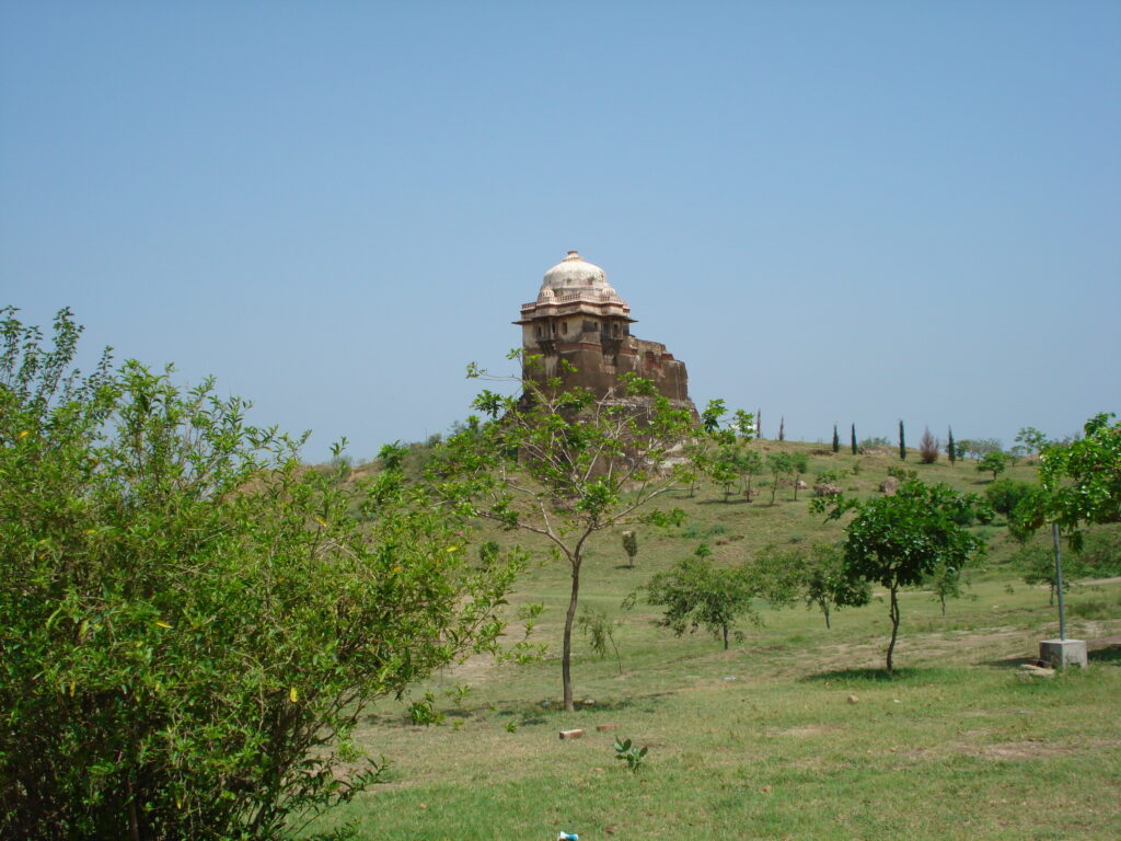
4.5.7 RANI’S MAHAL
It is a small building on the north side of the Maan Singh’s Haveli. The location
of the Mahal indicates that it was a part of the Royal Chambers i.e. the Haveli
Maan Singh. Historical records revealed that this small but prestigious building
was the residence of Maan Singh’s Sister. Major portion of the building has
vanished only a small room with dome on top has been able to with stand the
vagaries of time and weather. The bricks have been laid in lime mortar and
plastered neatly. The dome is proportioned nicely and gives an elegant look. At
present cracks are visible in the walls and need attention. The mound on which
Rani’s Mahal is located is a good Archeological site and can reveal information if
excavation is carried out by the specialists.
4.5.8 BAOLIS
There are three baoli’s in the Rohtas Fort. The baoli’s have been located keeping
in view the user requirements. The baoli’s have been named as under.
a. Shahi Baoli.
b. Langer Khani Baoli.
c. Tulla Mori Gate Baoli.
These baolis are discussed below.
Shahi Baoli.
This baoli is located in the Royal Chambers area at the back of the Shahi Mosque.
The baoli and the steps leading to the water lime have been constructed with bricks
laid in lime mortar. Staircases have fine and intricate patterns. There are sixty steps
leading down to the water line. There are small chambers around the baoli
presumably for relaxation of the royal family. Shafts have been provided in the stairs
cases for the height and the fresh air. It is a fine piece of Architecture and
Engineering. At present the baoli is not in use and requires cleaning to identify
conservation needs.
Langer Khani Baoli.
This baoli is located in the possibly the main entrance to the Royal area. The baoli
is located close to the Kahan river, and has a shallow depth compared to the Tulla
Mori Gate and Shahi Baoli. The baoli is constructed in bricks laid in lime are in
poor shape, party filled/ covered with earth and needs cleaning and restoration.
Tulla Mori Gate Baoli.
The baoli has been constructed near the Tulla Mori Gate by cutting deep into the
lime rock. This is the deepest and the biggest of all the baolis. One hundred and
forty eight steps each about 20 centimeters lead to the water line. The steps,
sidewalls and the upper portion of the well have been constructed in stone laid in
lime mortar. This baoli was a general-purpose baoli with the highest yield. This
was meant for the use of the entire army and the animals in the use of the Sher
Shah’s army. This is simplest in Architecture but a masterpiece of engineering as
the stones walls on either side of the steps leading to the water lime have been
properly strengthened by the use of arches and the tie beams. There must have
been a roof and some sort of water extraction arrangement but that is non existent
today, even the water storage tanks meant for the animals and the washing
purposes have not been able to with stand the onslaught of time and weather. The
baoli is not in use and needs cleaning and re-commissioning.
4.5.9 SIKH MONUMENTS: CHOA GURU NANAK AND JANAM ASTHAN
MATA KAUR.
There are two Sikh Monuments in the area; one of the monuments is located in
the Fort and the other is just out side the Talaqi Gates.
Choa Guru Nanak.
This is a Sikh Gurdawara almost square in shape and is located adjacent to a
natural spring on the bank of Kahan River out side the Talaqi Gate. It is a threestory
building with a small but magnificent dome in the center portion of the
building. It is very similar to the Gurdawara Siri Ram Das, Chuna Mandi Lahore.
The building has constructed in brick and plastered neatly.
There is a medium size water pond located on the south side of the Gurdawara for
the sacred bath by the pilgrims visiting the Gurdawara. Carefully scrutiny of the
building indicated that a stair case was added to the building at a later stage on the
east side of the building for the use of the Sikh Garanthees (Priests) to take the
Garanth Sahib to the dome at top of the building for sleep at night. This portion is
not monolithic with the original Gurdawara. The building is not in use and need
repairs and maintenance.
Janam Asthan Mata Kaur.
This is a small room with a dome on top. The building has been constructed with
properly dressed sand stone blocks laid in leveled courses. The legend says that
this is the birthplace of Mata Kaur the wife of the 10th Guru of the Sikh’s Guru
Govind Singh. The toilet constructed by a neighbor with the northern wall of this
sacred shrine is damaging the basic structure. This is an indication of the lack of
appreciation and awareness of the local community of the historicity and
sacredness of the structures.
4.5.10 HINDU TEMPLE
It is a small building located on the east side of the Rohtas Village near the Tulla
Mori Gate Baoli. It is typical of a small Hindu Mandar i.e. a square room with a
tapering roof. The building is not in use and is surrounded by the shrubs and the
wild growth. It is built in brick and plastered neatly. The local community’s
attitude towards this structure is again an indication of a lack of respect for a
structure belonging to another religious sect.
4.6 ROHTAS DRAINAGE
Drainage plays a very important role in the conservation and maintenance of
all types of structures. Efficient drainage enhances the life span of a
structure, reduces maintenance cost and chances of settlement. Poor
drainage reduces the life of a structure, enhances the maintenance cost and
contributes to rapid deterioration of a structure. At the time of construction
of Rohtas Fort it was provided with well planned drainage system but over
the period of time due to lack of maintenance this system collapsed and needs
rehabilitation.
Today the system can be divided into three major parts depending on the
topography of the area which one as follows.
- Area east side of road liking Khawas Khani Gate with Sohail Gate.
- Area between dividing wall and road liking Khawas Khani Gate with
Sohail Gate. - Andrakot / citadel area i.e. area on west side of dividing wall.
Map No. 13 Shows the Existing Drainage Condition.
The descriptions of these areas are discussed below.
4.6.1. Area east side of road linking Khawas Khani Gate with Sohail Gate.
Area east of road linking Khawas Khani Gate with Sohail Gate can further
be subdivided in the following zones.
a. Area between Sohail Gate and Sar Gate.
b. Area between Sar Gate and Peepal Wala Gate.
c. Area between Peepal Wala Gate & Tulla Mori Gate.
d. Area between Tulla Mori Gate and Gatayli Gate.
e. Area between Gatayli Gate and Khawas Khani Gate.
In the succeeding paragraphs drainage of area on the eastern side of road
linking Sohail Gate with Khawas Khani Gate will be discussed under the
following headings.
Area between Sohail Gate and Sar Gate.
In this area there is only one out let in the wall for the drainage of the storm water
near the graveyard located on the south side of the Eid-Gah. The outlet stands
choked today and is not in use rather has become unserviceable. The area was
examined critically and observed which yielded the following:
i. Height of ground at the mouth of out let is 290.
ii. Height of ground at about fifty feet from outlet is 292.
iii. Height of ground at four hundred feet from wall/outlet is 288.
iv. Height of ground at a distance of about 800 feet is 286.
v. Floor level of Sohail Gate is 300.
From the above data it is clear that at the time of construction of fort the water
was flowing out from this drainage point. In the later years the exit got blocked /
choked due to unknown reasons probably due to lack of maintenance thus the
water changed it’s course and started flowing in the north eastern direction. As the
soil is sandy in nature therefore it did not offer any substantial resistance to the
water and over the years the drainage pattern changed from south to northeast. In
this area sand stone rocks are exposed and the storm water has washed the fines
away.
b. Area between Sar Gate and Peepal Wala Gate.
There is no outlet for storm water in the Fort Wall between these two gates. The
physical examination of the area and the careful study of the latest topographic
survey map reveal the following.
i. The area was generally flat in nature and the two small gates i.e. Sar Gate
and the Peepal Wala Gate were serving as drainage outlets.
ii. Height of bed level of Sar Gate is 290.
iii. Natural surface level of ground 100 feet away from Sar gate near the
second Bastion on East of Sar Gate is 290.
iv. N.S.L near the 3rd Bastion on east of Sar Gate is 288.
v. N.S.L near the 4th Bastion where the wall change direction from east to
North is 286.
Bed level of Peepal Wala Gate is 282.
vii. N.S.L adjacent to Peepal Wala Gate is 286.
The study of the contours indicates that initially the ground was sloping towards
the Peepal Wala Gate and the gate was serving as drainage outlet but with the
expansion of Rohtas village the area was leveled and converted to play grounds
thus changing the original drainage pattern. This has resulted in the reversing of
natural slope and now the water is flowing in the northern direction in the shape
of a nullah at a distance of about 150’ feet from the eastern wall and almost
parallel to the wall. The change of original drainage plan has resulted in excessive
erosion, washing away of topsoil, exposure of sand stone rocks, decrease in
vegetation and damage to environment.
Area between Peepal Wala Gate & Tulla Mori Gate.
There is no drainage outlet between these two gates which is a clear indication
that the gates were also to serve as drainage outlets, the study of contours on the
topographic maps also confirm the general layout of the area but the ground
reality is as follows.
i. Bed Level of Tulla Mori Exit is 286.
ii. Bed Level of Tulla Mori inlet is 284.
iii. Bed Level of Tulla Mori near Bari Baoli adjacent to Tulla Mori Gate is 280.
The study of the levels confirms the reversing of natural slopes. Today no water is
flowing out from the Tulla Mori Gate rather the water is flowing in the western
direction and discharging into nullah on west of Bari Baoli for further disposal.
d. Area between Tulla Mori Gate and Gatayli Gate.
The area between these two gates is roughly level and is served by six drainage
outlets which are located at regular intervals. All the out lets are functional and
are serving the purpose for which they were designed. The area slopes from the
village towards the eastern wall and is well drained. There are few shallow ponds
that have been constructed for storage of storm water. The slopes are gentler and
very little effort is required to control the erosion.
The outlet located on the north side of the Tulla Mori Gate is very heavy loaded
as it is taking the entire load of area located between eastern fortification wall,
Southern wall up to Sohail Gate, Road connecting Sohail Gate with over head
water reservoir on the west and part of the Rohtas Village Separated by a line
connecting over head water reservoir with Hindu Temples through Mohallah
Baluchan. This measures almost 1/5 of the total area to be drained. The steep
slopes in the catchment area described above have resulted in excessive run off,
flow of water at great speed, washing of topsoil, erosion of sandy soil and creation
of nullah from Sar Gate to this outlet. The outlet is narrow compared to the water
that it is to discharge in a short span of time. This has resulted in the washing
away of the soil on the outer side of the fort wall, which was so very important for
the safety, and the support of the wall. Today the foundation of the outer portion
of the wall is totally exposed and is hanging precariously in the air.
This needs under pining on emergency basis to avert imminent danger of it’s
collapse. Some protective works to control further erosion and speed of water are
also required. A separate study by a team of specialists is required to control
excessive erosion and arrest any further damage to the vary precious Fort
Structures.
e. Area between Gatayli Gate and Khawas Khani Gate.
There are two drainage out lets between Gatayli Gate and the Khawas Khani
Gate. Both the out lets are in fairly good condition and are functional. The
drainage area slopes from south to north therefore the drainage is efficient and the
area is well drained. In addition to the two outlets Gatayli Gate is also serving as
drainage point due to lowering of levels of track entering from the Gatayli Gate
and leading to the village.
The inspection of the area at the exit of the out lets have shown that the drainage
channels out side the fort wall have never been maintained and as a result erosion
of Gatayli Gate entrance steps and north side bastion took place in addition to the
wall on the north side of the Grave Yard. The drainage channels out side the fort
need cleaning and proper maintenance / diversion of Storm Water to safe guard
against any further erosion of the perimeter wall structures.
4.6.2 Area Between Dividing Wall And The Road Linking Khawas Khani Gate
And Sohail Gate.
Topographically the area slopes in two direction i.e. North & South, therefore
drainage out lets were provided in the perimeter wall on the north & the south.
The water flows in the northern direction from the ridge line connecting DOAM
office with the Haveli Maan Singh / Rani Mahal as well as in the southern
direction, thus the area will be discussed under the following sub headings.
a. Area between Khawas Khani Gate and inner dividing wall up to foot track
connecting Haveli Maan Singh with DOAM office in the South.
b. Area between Shah Chand Wali Gate, Sohail Gate & Foot track
connecting Haveli Maan Singh with the DOAM office in the North.
The above zones are discussed in detail below.
a. Area between Khawas Khani Gate and inner dividing wall up to foot track
connecting Haveli Maan Singh with DOAM office in the South.
The above area can be subdivided into following zones.
i. Area between Khawas Khani Gate
and Kashmiri Gate.
There are three drainage out lets between these two gates and all of them
are choked and non functional. This is a result of lack of maintenance and
unplanned / haphazard construction activity in the fort area. The initial
slopes were from south to north but now the water from the village is
flowing out through the Khawas Khani Gate and the Kashmiri gate. Area
near the drainage out lets is littered with animal and human excreta and
waste materials dumped by the inhabitants of the village, thus disturbing
the designed drainage pattern and the natural slopes.
ii. Area between Kashmiri Gate and the Inner Citadel Dividing Wall.
There are three drainage outlets in this area out of which two are choked
and nonfunctional: only one outlet located near the citadel wall is
functional. This outlet is taking the entire load of the triangular area
circum- fenced by the citadel wall on the west & south west, road linking
Sohail Gate with Khawas Khani Gate in the east and the fort wall between
Khawas Khani Gate and the citadel wall as all other out lets in the area are
choked and non operative.
Diversion of the water from the other drainage outlets has changed the
entire drainage pattern which has resulted in rapid erosion of soil along the
dividing / citadel wall thus exposing its foundations and resulting in
collapse of it’s major portion.
A comprehensive study of this area is required by a team of specialists to
ascertain the original level of this drainage out let as the Fort wall between
the dividing wall and the bastion on the east of it seems to be a
reconstruction. A very careful analysis of the present / existing situation is
required to assess / ascertain the change in level of drainage out let and the
reconstruction of the collapsed wall to come to a final conclusion
regarding the originally designed drainage patterns.
Area between Shah Chand Wali Gate, Sohail Gate and Foot Track
Connecting Haveli Maan Singh with DOAM Offices.
This is a terraced area sloping from north to south and is drained by two drainage
outlets in southern perimeter wall. The higher terrace adjacent to road linking
Sohail Gate with the Khawas Khani Gate has a level of 298 and extends up to
track linking Haveli Maan Singh with DOAM office. The lower terrace adjacent
to Shah Chand Wali Gate has a level of 292. Both the outlets are functional and
draining the area effectively. It is however pertinent to mention that the wall at the
exit of the outlet near the Shah Chand Wali Gate is damaged and needs corrective
measures.
If the Conservation works are not taken in hand on priority basis the condition of
already damaged perimeter wall will be aggravated due to erosion by the storm
drainage through this outlet.
4.6.3 Andarkot/Citadel Area i.e. Area on West Side of Dividing Wall.
The area between the dividing wall and the western perimeter wall slopes in the
western direction i.e. towards Kahan River except a very small portion south of
Haveli Maan Singh, which slopes towards south. The slopes are adequate thus the
area is well drained. Almost all the drainage outlets shown on the topographic
survey sheets are choked and non functional. At present the water is flowing out
through Talaqi gate, a gap in the perimeter wall between Shishi Gate and Shahi
Gate, Shahi Gate and from under the foundation of perimeter wall at two locations
south of Haveli Maan Singh. DOAM is currently making efforts to locate and
unearth hidden outlets in general area.
The area has been subdivided in to following zones for drainage purposes.
a. Area between inner wall (citadel wall) and the Talaqi Gate.
b. Area between Talaqi gate and Langar Khani Gate.
c. Area between Langar Khani Gate and Shahi Gate.
d. Area between Shahi Gate and Shah Chand Wali Gate.
These areas will be discussed in detail below:
a. Area between Citadel Wall and the Talaqi Gate.
There is only one drainage out let in this area, which is blocked and nonoperative,
which certifies that the water is draining out through Talaqi Gate. In
this area the slopes are gentler and the area slopes from east to west and
northwest. The highest level near the citadel wall is 286 and the lowest point
slightly to the south of Talaqi Gate is 270 where as bed level of Talaqi gate is 280.
b. Area between Talaqi Gate and Langer Khani Gate.
At present no drainage outlet is visible between these two gates along the inner
perimeter wall. Detailed reconnaissance of the Langer Khani area has revealed
presence of two drainage outlets i.e one in the wall between Langar Khani gate
and the Shishi gate and the 2nd in the wall separating the kitchen area from the
main fort. The inlet of the drainage out in the inner wall is blocked. Archeological
investigation is required to arrange digging and unearthing of the inlet. At present
the entire water in draining out from Talaqi gate, which is not a desirable
situation.
c. Area between Langer Khani Gate & the Shahi Gate.
This area has lost its original slopes thus disturbing the drainage pattern between
the above-referred gates. The outer perimeter wall has collapsed at number of
places, giving rise to a major nullah and a number of small nullahs. Investigations
are needed by a team of experts comprising of archeologists, geologists,
hydrologists & engineers to ascertain the causes of damage to the Fort wall in this
area and the change in over all drainage pattern. A lot of topsoil has been lost as a
result of erosion and increase in storm water channel bed slopes.
The highest point in the area is Ziarat Dheri Sain Sattar. The highest level is 290
and the lowest point i.e. the nullah bed is 270m and the Kahan River west of wall
has a bed level of 240. This indicates a level differences of 50 meter in a distance
of about 150 meters. This is the most undesirable slope (1:3) as it encourages
rapid erosion & loss of precious topsoil.
d. Area between Shahi Gate and Shah Chand Wali Gate.
There are only two drainage outlets in this area out of which are has been
unearthed recently by a team of Archeologists and engineers from
Department of Archeology and Museums Government of Pakistan. The outer
side of the drainage out let is in a dilapidated state and needs lot of
conservation works. The area slopes from North to South and South West
from a Kacha (unpaved) track linking Rani Mahal with Shahi Gate. The
highest point between Haveli Maan Singh and Rani Mahal is 300 and the
lowest point near the drainage out let is 284. The drainage structure at the
exit of the drainage out let has mostly disappeared and parts of washed away
structure are lying in the nullah bed out side the fort wall. Restoration and
Rehabilitation effort is required to repair the drainage outlet to control
erosion along the foundation of the Fort Wall. The second outlet located
between Phansi Ghat and Shah Chand Wali Gate is yet to located and
unearthed.
CONSERVATION WORKS
HWF’s conservation efforts have been undertaken based on complete
documentation of:
- Shah Chand Wali Gate.
- Talaqi Gate.
- Gatayli Gate.
- Maan Singh’s Haveli
A visitor center has been developed on the ground floor of the Sohail Gate. A
museum is in the process of being established on the top floor of Sohail Gate The
HWF has been documenting the areas of the fort as and when required to
undertake conservation / restoration works.
4.8 GEOLOGICAL CONDITIONS
Rohtas Fort is located on sand stone of Siwalik age rocks. Siwalik rocks are
considered as the youngest rocks. They mainly consist of sand stone, shale and
sometime mudstone. Conglomerate and alluvium are also major contents of
Siwalik rocks. This formation starts from upstream of Mangla Lake and extends
up to edge of Salt Range.
As these rocks are of youngest age, their strength is not so much like other
sedimentary rocks, e.g. Murree formation consisting of sand stone of Miocene
age. Siwalik rocks are friable and they accept immediate affect of weathering.
Erosion factor plays an also very important role in their behavior. In the project
area a lot of erosion is observed and there must be some treatment for the
deformation of rocks underlying the walls of fort. Storm water drainage is also
playing an important role in the erosion of these soft rocks.
In the area of Shah Chand Wali Gate of the Fort, water percolation is observed as
it is percolating from one side of the walls towards the other side. It can create
further deformation problems. Hence detailed geological field and laboratory
work is needed on the disturbed areas of the Project. Weathering effects are also
commonly observed in the vicinity of Haveli Maan Singh. Surface rocks are
showing weathering effects and erosion is weakening the foundation of the
structure.
SECTION – 5
ISSUES
CURRENT CONTEXT AND ISSUES
5.1 CONSERVATION ISSUES
Today Rohtas Fort stands as monument of its time but is in a state of dereliction
due to environmental and climatic impact on its structure, low maintenance,
impact of the village residents, and poor conservation works. The poor
presentation of the fort does not provide visitors with adequate information or
history about the fort. HWF efforts to improve the situation are commendable
however the performance of the government to protect its heritage has been very
poor. HWF’s interventions have essentially led to the awakening of the
government and DOAM to allocate a budget of Rs.163 Million for conservation
works in 2005
5.1.1. Overall Conservation Approach
Conservation efforts at the Rohtas have been made during the British Period, and
the Department of Archeology after 1947. By and large all these efforts have been
characterized by the lack of a comprehensive plan based on accurate assessment
of need and on international standards. This is true not only for the Rohtas Fort
but it can be said for most of the works of the department. The approach to
conservation has tended towards:
Reactive conservation without assessment of need and clear statement of
priorities;
Carrying out interventions without proper study, documentation or
preparation before hand;
Dealing with surface appearance without addressing serious structural
issues;
Partial or full reconstruction of structures on the basis of insufficient
research and without clear identification of “new” vs. “original”.
Replacing faded or slightly damaged original elements with new copies in
similar materials;
5.1.2 Prioritizing Critical Conservation
Issues
The details of the existing condition and the reasons for the existing condition have
been dealt with in the Condition Survey of Rohtas Fort as a Annexure volume to this
report.
Since the Unicon team has conducted a visual survey of the fort and no detailed
documentation is available apart from the HWF’s efforts of the conservation
works undertaken on the three gates cost estimates of the conservation works of
the Fort can only be approximated. However rate analysis of the type of repairs
can assist in calculating the cost of the stabilizing and conservation of the
structures.
A number of actions are immediately required to arrest further deterioration of the
fort and detailed studies are also required to analyze the extent of damage and to
take preventative action against further deterioration.
The most critical conservation issue is to stop the deterioration of the fortification
wall. The primary reasons for the deterioration are:
a) Damage due to water percolation from storm drainage from the inside of the
fort
b) Water penetration from cracks in the walkways and terraces along the walls
c) Scouring of the walls due to weathering and water penetration
5.1.3 Procedures for Implementation of Conservation Work
Conservation work is being carried on at Rohtas without sufficiently standardized
procedures. There is a need to clearly identify the steps to be carried out in order
to ensure that all work is justified, carefully planned and implemented. Not only is
a priority list of works needs to be prepared, works must follow international sets
of guidelines. At present there is little reference to the many international
guidelines, manuals and case studies available. Work in other parts of the world
would provide useful models and provide new ideas and approaches.
5.1.4 Documentation
One of the fundamental management tasks at a World Heritage site is to fully
document the site using a variety of media and methods, including maps, plans,
architectural details, photographs, film and text. Custodians must also record in
detail every intervention into the fabric and form of the site, documenting it again
in a series of before and after presentations.
There was no accurate topographic survey of the fort available. HWF had
requested the Pakistan Army to document the site. However, the topographic
maps prepared did not have adequate detail. A detailed topographic survey of the
site has been undertaken as a first step to initiate the documentation process (See
Map 14). This plan has documented contours on every one meter; it also indicates
the places where the wall is damaged, broken or scoured. The location of the
majority of the original drainage channels in the walls will form the basis of
designing the drainage patterns of the fort considering that the original
topography has changed over the years and the drainage holes are blocked
There are records available with the Department of Archeology (DOAM)
however they have not been maintained systematically or in a comprehensive
manner. The DOAM has graphic and photographic records of all the gates and the
areas where conservation efforts have been made over the last 50 years. The
UNICON team has undertaken the task of photographing the Rohtas Fort. The
new photographs are compared with the older photographs and all the changes
documented to assess the damage done during the last fifty years or so. This
forms part of the Condition Survey Document attached as an annexure.
HWF established a documentation center for the purposes of undertaking the
conservation projects. The works undertaken on Shah Chand Wali Gate, Talaqi Gate
and Gatayli Gate have been documented before and after conservation works on
AutoCAD and photography. However, HWF and DOAM need to establish a
systematic and standardized procedure possibly on the same lines as the UNESCO
NORAD Shahi Qila Project. A standardized format as used is attached in the
annexure.
5.1.5 Archaeological digs and
excavations
Except for the fortification wall, the three standing structures in the Andarkot and the
Baolis there seem to be no other struc tures that can be dated to the Suri/Mughal
period that are still standing. The topography of the inner area has changed
considerably due to erosion and fill. The Rohtas town has extended itself and some
remains of older structures are visible as walls of the existing homes. There are a
number of walls of the residences within the Rohtas Fort that can possibly be dated to
over 100 years. Considering the fact that the construction of residences has taken
place in this specific area of the fort indicates the possibility of earlier structures and
therefore finding archaeological remain within the town area are high. It is necessary
that archaeological digs be conducted to identify older remains as well as to
understand how the fort areas were utilized.
5.1.6 Skilled Artisans in Stone Construction and Traditional Building Crafts.
Rohtas Fort essentially comprises stone works laid in lime mortar. Rohtas Fort
may not have the extensive crafts seen in some of the Mughal monuments,
however the craftsman ship for stone masonry, stone carving, frescoes and marble
require training. A system of identifying the composition of the materials used has
to be undertaken in a scientific manner. An adequately equipped laboratory
facility designed to meet the needs of monitoring, maintenance and conservation
of the World Heritage site is essential. DOAM has lab facilities at the Lahore Fort
comprising a tile workshop and a lime laboratory. Testing of materials of work
that is ongoing on the Rohtas Fort has to be sent to Lahore, considering that the
crafts existing in the Rohtas fort is limited. It is seen that DOAM has used cement
and new materials for repair and conservation thereby losing on all the originality
and authenticity of the monument. Moreover Conservation works demand a
skilled workforce of artisans trained in traditional building craft. Today artisans
skilled in the traditional crafts are an almost lost profession. Very often works are
let out to contractors who may or may not employ the best artisans. Contracting
practice has to be discouraged in conservation works. The department should train
its own artisans. These artisans should be encouraged to design and develop new
products for sale, in the process training additional apprentices on the same lines
as it is being done at the Shahi Qila, Lahore. The community living in Rohtas
town could be given incentives to attend training programs for income generation.
ISSUES:
Issue 1: The lack of set priorities for addressing the many critical
conservation situations
Issue 2: The need for an updated, professional overall approach to planning
and implementing conservation in keeping with international
standards and guidelines.
Issue 3: The importance of a detailed and standardized documentation
system.
Issue 4: The need for archaeological surveys and digs.
Issue 5: The shortage of trained skilled artisans in traditional building crafts
to carry out conservation work.
Issue 6: Employment of unskilled contractors.
SITE MANAGEMENT ISSUES
5.2.1 Custodianship and Oversight
The custodian of Rohtas Fort is the Federal Department of Archaeology.
However their efforts in maintaining the site and conserving the world
heritage site has been very poor. City Government has had no involvement in
the administration of heritage sites, since the effort of safeguarding was
considered the responsibility of the Federal Government. Moreover, due to a
lack of a coordinating mechanism, Provincial and City Governments have
not felt that they neede d to provide any assistance for the protection of the
monument leaving it to the Federal Government and DOAM to undertake
any protective measures.
Himalayan Wildlife Foundation an NGO has played a pivotal role in drawing the
attention of the Federal Ministry to the lack of attention given to the Rohtas Fort,
a World Heritage site since 1997. In the last five years the HWF has been very
actively involved in the Rohtas Fort and has managed to mobilize the ministry to
provide them access and undertake conservation and restoration works in the
Rohtas fort. They have mobilized the community and the local government and
have undertaken development activities within the village. This has resulted in
clearing the environment within the village where sanitation systems have been
installed and roads have been paved. The negative impact of this development has
been increased encroachments and construction of unauthorized building activity.
The official tourism authorities, PTDC and TDCP presently play no role in
management or directly promoting tourism at this World Heritage Site. The
site forms part of the tour itineraries promoted by PTDC and TDCP, but the
organizations do not conduct special tours or provide special promotional
material. Local tour operators are also not involved in any campaigns for
heritage site promotion. They do not provide guides nor do they arrange any
special activities or events.
The general lack of a coordinated strategic approach to cultural heritage
management has encouraged ad hoc decision making, resource allocation and
conservation practice. The competence of cultural heritage managers is part of the
problem as their qualifications and practical experience may not equip them well for
their roles. In addition they do not have the resources or support in terms of adequate
staff to implement standard conservation methodologies and to link those to a
strategic plan.
There is no regular inspection of the systems and works of the site
management by any external agency. What needs to be done , how it is to be
done and whether it is of acceptable international standard, were decisions
taken entirely by the Department of Archaeology (DOAM) itself. The
Steering Committee established through the efforts of HWF is now playing
the role of a monitor of all works being done at the site. However in the last
five years the works are being done entirely by the NGO with the department
taking a complete back seat.
5.2.2 Enforcement of Legal Protection
The Federal Antiquities Act provides various forms of legal protection in support
of preservation of a World Heritage Site, however there is a failure to take
advantage of this potential and the site suffers.
Although the Federal Antiquities Act 1975 (Act VII of 1976) stipulates
that the Federal Government will constitute an Advisory Committee
(Clause 3), no committee seems to be in existence
Clause 18 of the Act is clear regarding the use that the protected
monument or site may be put to. However, the spirit and letter of this
clause are not enforced when permission is given for events to be held.
HWF has organized annual events for fundraising for the Fort with
permission from the Ministry however an impact assessment of such
events on the fragile structures of the fort needs to undertaken.
In spite of the stringent fines and punishments that are laid out in Clause
19 for willful damage to a monument, it has not been possible for the
Department to protect the various structures from graffiti and other forms
of vandalism. Among the problems are the lack of sufficient number of
guards, but also the problem in enforcing punishment since the
Department does not enjoy magistrate’s powers necessary for
enforcement.
Clause 22 requires that “no development plan or scheme or new
construction on, or within a distance of two hundred feet of a protected
immovable antiquity shall be undertaken or executed except with the
approval of the Director General;” however the community living within
the Fort itself continues to construct and expand. The DOAM has been
unable to enforce this regulation due to shortage of staff and the lack of
engagement of provincial and local government in enforcing the above
clause. A clear cut buffer zone does not exist due to the topography of the
area. A 75 meter buffer zone around the perimeter wall has been
transferred to DOAM since 1993, however a proposal extending the area
to 750-1500 meters is still pending with the Punjab Government and the
land is in control of Forest Department.
In 2004 the HWF managed to convince the Ministry to constitute a
Steering Committee on restoration and conservation of Rohtas Fort as
under:-
i) Secretary,
Minorities, Culture, Sports, Tourism and Youth Affairs Chairman
ii) Director, UNESCO Member
iii) Director General, Department of Archaeology and
Museums, Karachi. Member
iv) Director, Northern Circle of Archaeology, Lahore. Member/
Secretary
v) Zila Nazim, Jhelum Member
vi) Representative of HQ 1 Corps As observer
vii) Representatives of Himalayan Wildlife Foundation,
Shell Pakistan Limited and all donors. Co-opted
Members
Although the DOAM is represented in the Steering Committee its
involvement in the conservation works being done is limited due to lack of
staff. It is only in January 2006 that a Project Director has been in place to
oversee the works of the approved PC-1 2005. The Steering Committee
has also constituted a Rohtas Fort Management Committee, which
includes members from the community of Rohtas Town.
5.2.3 Staffing
The staff deputed by DOAM at the world heritage site is far short of the
requirements specially keeping in view the vast area that it covers. A staff of
four persons is the total staff strength allotted to the fort. There is only one
archaeological officer along with a staff of three others (out of which one post
has been lying vacant) to carry out maintenance/ monitoring works at Rohtas
Fort. A conservation assistant who is often deputed to other works and a
junior archaeological officer has been posted temporarily are the only
technical persons to look after the conservation maintenance and monitoring
needs of such a large complex.
The recently approved PC-I by the Federal Government has recommended a list
of staff headed by a Project Director, which will improve the situation. However
due to a shortage of availability of trained archeologist and architects, the
positions are yet to be filled.
Development schemes and PC-1 s
Conservation and development Schemes for Rohtas have taken the form of PC-1
documents. These are designed to serve as applicatio ns for government funds for
specific works, giving a brief background of proposed works and quotations for
manpower and materials. The PC-1 normally provides only general information
on civil works items. Schemes prepared on PC-1 Performa lack detailed
justification for proposed works; the information given on the Performa fails to
provide details regarding location and measurements of an item of work and thus
cannot be a substitute for a full and detailed report.
The lack of detailed work specifications as a part of the PC-1 Performa leaves the
use of funds and decisions regarding treatment of historic fabric mostly to the
discretion of the site supervisor. Much of the unfortunate and unnecessary
intervention in evidence is likely to be due to these discretionary powers allowed
under the present system. The conservation of monuments or archaeological sites
requires special expertise in order to cope with unexpected findings, their
interpretation and treatment. Too often, a contractor appointed through the
government tender system does not have these skills and uses inappropriate tools
and methods on historic fabric. The contract system has resulted in a great deal of
sub-standard conservation work and irreversible loss of integrity to historic
monuments
Almost all schemes were revised repeatedly, in many cases because funds were
not provided according to the phasing envisaged in the scheme. As a result no
scheme has been completed on time. The formulation of a new scheme or project
document while previous ones are still in progress has created problems for the
staff of the DOAM, as the increase in work is not matched by additional staffing.
The result is that normal maintenance and repairs are abandoned and all buildings
not included in the new Schemes suffer further neglect. The lists of PC-1 prepared
by the department to date are as follows:
A PC-1 document was prepared in 1990 with a cost of Rs.19.47
Million. The Ministry of Culture approved it at a much-reduced cost
of Rs.4.8 Million. The amount that was realized was subsequently
even less than the actual requirement.
In 1999 the Governor of Punjab emphasized on the preparation of a
master plan and the department requested NFCH for the provision of
Rs.1.326 Million, Unfortunately, funds were not released by the
NFCH and no work was carried out.
In 2000, the department prepared 10 schemes in the form of PC-1,
which were again not approved due to a ban on new schemes.
In January 2004 in the meeting of the Steering Committee the DOAM
presented an outline of a Master Plan to be prepared for the
conservation and preservation of the fort. The Secretary Culture
observed that the Master Plan would take some time for finalization
and the department should initiate stabilization work and all the PC-
1’s submitted earlier should be combined, its costs revised and
submitted for approval to the ministry.
This PC1 has now been approved and it includes the hiring of professional
staff with a Project Director heading a team of professionals including
architects archaeologists, conservators and supervisory staff. The hiring of
this staff is in process at the time of the writing of this document. Some
limited staff is already in place.
5.2.5 Funding Procedures
Financial Management
As with other government departments, the financial management with the federal
Department of Archaeology (DOAM) was equally poor. There were a number of
bureaucratic channels before the money could actually be spent on the
monuments. This was probably because of the fact that all the financial powers
were with the Director General whose offices are in Karachi. The Director
Northern Circle had limited powers to spend as small an amount as Rs. 25000/=.
Any amount beyond this required the approval of the Director General in Karachi
and the Federal Ministry in Islamabad. The budget estimates kept shuttling
between Lahore, Karachi and Islamabad leaving very little time for actual
physical implementation before the end of the fiscal year. These bottlenecks
caused unnecessary delays and the monuments suffered.
There are a number of bureaucratic obstacles to be overcome before federal funds
can be spent on the Fort. The national budget is announced in June but it takes
several months before the information reaches the Department of Archaeology
(DOAM) and its regional offices. The amounts are then allotted to various
monuments. But the process for making actual expenditures is lengthy and
bureaucratic. The Director has the power to spend up to only Rs. 25,000. Beyond
this sum, detailed conservation pla ns and budget estimates in the form of
Conservation Notes are prepared for the approval of the Director
General/Ministry. The process can only be completed by the end of November or
early December, when half the fiscal year has already passed. The budget
estimates then pass between offices until all objections and queries are settled, a
process that may take several more months. As a result, the earliest that approval
can be received is the middle or end of April. This leaves only two months in
which the Department of Archaeology (DOAM) must carry out implementation of
all the works before the end of the fiscal year. There is inevitable pressure to
finish the work quickly. Hasty execution and dependence on ‘replacement and
reconstruction that can be carried out quickly, rather than painstaking preventive
conservation, can be directly attributed to this system for the release of funding”.
With a Project Director (PD) now in place conservation works at Rohtas by the
Department of Archaeology (DOAM) may significantly improve. However, it is
the motivation of the PD that will ensure improved and efficient implementation.
HWF has managed to raise funds from NFCH as well as from other donors.
Through the Steering Committee, it has got approval to collect gate money and
deposit it with the District Coordination Officer (DCO). The Management
Committee of Rohtas Fort manages this money.
Financial Situation
The financial situation of the Federal Department of Archaeology (DOAM) in
respect of Rohtas Fort is now fair ly encouraging, Apart from the routine budget
allocation for the Department of Archaeology (DOAM), the Federal government has
provided a large sum of money i.e Rs.163.000 million to be utilized in the next five
years for this world heritage site through the approval of the above mentioned PC-1.
5.2.6 Training
The only training institute available is the Pakistan Institute of Archaeological Training and Research in Pakistan
(PIATR) at the Lahore Fort. Although architecture is taught at various institutions including the National College
of Arts and University of Engineering and Technology, Lahore no degree course is offered in conservation and
traditional building methods and building crafts. The only conservation course that has been initiated recently is at
the NED University, Karachi. National College of Arts is in the process of establishing a program in conservation
and management studies. These are two institutions offering degree programs in archeology in Peshawar University
& Punjab University.
Since much of protected heritage consists of standing monuments, it is essential to
provide conservation training to architects and engineers. The lack of sufficient
technical expertise within the DOAM has been identified as one of the key causes
for inappropriate conservation works. By instituting conservation courses within
architectural and engineering schools and the PIATR, the Department of
Archaeology (DOAM) will be strengthened through induction of technical
personnel who are conversant with conservation issues and will be able to oversee
works required for safeguarding heritage assets.
The staff at DOAM requires specific training and core competency training
programs. UNESCO could act as a key agent to provide assistance in the form of
workshops and short courses for the staff. Standard operating procedures for each
job need to be put in place and the staff should be fully conversant with these
procedures before undertaking any action
ISSUES:
Issue 1: The need for a structured, multi– stakeholder management system
to guide conservation and management
Issue 2: A broader based and more efficient funding approach
Issue 3: The lack of trained manpower in conservation & related subjects.
Issue 4: The need for an improved and better-informed management team
to implement the master plan.
Issue 5: The need for core competency training at all levels of staff
Issue 6: The need for a clear definition of job scope in the form of SOPs
Table 5.2: Management Issues
MONITORING AND MAINTENANCE ISSUES
5.3.1 Routine Monitoring and Maintenance.
The DOAM carries out no comprehensive or systematic monitoring of building
condition and maintenance at Rohtas or any other site. This is in a large part due
to staffing limitations. Apart from technical staff, the basic staff of guards,
cleaners/sweepers, gardeners and a wide range of professional expertise needed
for safeguarding such a large monument are lacking, with inevitable results.
Routine maintenance is carried out on verbal instruction; systematic records are
kept only in exceptional circumstances. Separate systems do not exist for
monitoring the condition of the monuments and for implementing required
maintenance. There is only one team carrying out both with no system of
crosschecking and certification. In addition, no specific research or site
investigations are carried out in advance of conservation and maintenance
interventions.
5.3.2 Monitoring on Conservation Works
The Ministry of Culture, Sports, Youth Affairs and Tourism and the AG’s Office
carry out monitoring of conservation work carried out by the Department of
Archaeology (DOAM) on approved Development Schemes on PC- IV and PC-I
formats. These performas do not suit monitoring of conservation works as they
were designed for monitoring of new works and don’t provide adequate baseline
information about the buildings and interventions.
This extremely unsatisfactory state of affairs allows latitude to those who are
entrusted with the work of conservation. Due to a lack of an efficient reporting
and monitoring system, the works are carried out on the will of those executing
them without regard to the importance of following accepted conservation
principles. Since the quality and expertise of those executing the project varies
enormously, it is critical that all works are monitored carefully and diligently.
5.3.3 Maintenance of Ruins and Archaeological Remains
The site comprises essentially the fortification wall and a few structures. The
large open areas are covered with dry sub tropical evergreen and thorny
vegetation. No archaeological studies have been conducted and the possibility of
remains, under the structures of Rohtas Town and the vegetation is there. The
situation is further aggravated due to the terracing of land for agricultural
purposes within the fort specifically in the “Andarkot” and the change in the
original topography. Soil erosion over the years due to storm water has further led
to massive changes in the topography. A case in point is the change in the level of
the “Andarkot” area between Shahi Mosque and Maan Singh’s Haveli where the
original storm water channel in the fortification wall is buried 25 feet below the
current internal level. This is an indication of the changes in the topography due
to lack of maintenance and monitoring. It is seen in places that over 3 feet of
sweet soil has been added to the original levels. The ruins of Maan Singh’s Haveli
and Rani Mahal are not protected and people walk and climb over them possibly
resulting in loss of further archaeological evidence. Construction by the residents
of Rohtas Town continues unabated and there is no monitoring of the
developments that have taken place possibly on original historic structures.
Another source of damage is the constant damp state caused by storm water
drainage and the sewage disposal from the community living in the Rohtas town.
Currently the site is overgrown with wild vegetation; this is also seen on roofs of
the structures and the fortification wall. The ground vegetation does assist in
curtailing soil erosion of the open areas however the growth of plantation on the
structures is causing damage. The roots of the plants penetrate inside the
structures loosening the mortar thereby weakening the structure further.
ISSUES:
Issue 1: The lack of systems to carry out and record monitoring and lack of
systems to upkeep the site with regular program of maintenance
Issue 2: Lack of staff to undertake monitoring and maintenance
Issue 3: The need for a system to monitor conservation works carried out
by the department and under department supervision
Issue 4: The need for an approach to the maintenance of ruins and ground
level archaeological remains
Issue 5: The need to clear wild growth and a review of the planting regimen
in view of damage being caused to remains / structures /
foundations
Table 5.3 Monitoring and maintenance issues
ENVIRONMENTAL & PHYSICAL INFRASTRUCTURE ISSUES
5.4.1 Environmental Context
Rohtas Fort stands at an isolated ridge on the bank of River Kahan at a distance of
about 16 kilometers from Jhelum. It suffers all the universal negative impacts
experienced by heritage properties encircled by numerous nullahs and a turbulent
river, which is very harsh during rainy season. As the Fort was constructed purely
for military purpose therefore it was located on the highest ridgeline in the area
for better observation and defense of the fort. The location of fort is now making
the deterioration process quite rapid and needs concentrated efforts to preserve.
Effective preservatio n will require successfully addressing the issues of the
external environment and setting of the site. Its future is directly linked to issues
of erosion of soil, growing of grass and tall trees to control the effects of fast
winds and rain water. At present the world heritage site is a lacuna in the land use
with no recognition of the need to use planning tools to protect it and to maximize
it’s potential to generate cultural tourism related activities.
The fort is connected to the main N-5 Road by means of a narrow 12’-0 wide
metalled road. A bridge over the Kahan River has recently been built thereby
providing easier access to the fort. However the upgrading of the road has resulted
in increased urban development along the road. New buildings are being
constructed adjacent to the road thereby leaving no land for widening of the road.
This access road enters Rohtas Fort from the Khawas Khani Gate and exits from
Sohail Gate. The route is used by public and private vehicular transport upto Tilla
Joggian. All types of transport enter Rohtas fort for the purposes of providing
transport to the Rohtas town as well as a link to Tilla Joggian. The entrance from
Khawas Khani Gate through Rohtas Town is the only route for visitor to the Fort
creating an extremely poor image of the Fort.
In 1993 a buffer zone of 75’ meters was defined around the perimeter wall whose
ownership was also transferred to the Federal Government. Beyond most of the
land is in the possession of the Forest Department of the Government of Punjab.
Small private landowners also are involved in agriculture. The proximity of the
Kahan River adjacent to the mouth of the Fort has also damaged the Fort Walls
when in high flood. The only Suri period Maqbara stands outside the fort walls
indicating the possibility of additional archaeological remains just outside the
buffer zone.
A large village comprising over 400 houses (Population approximately 3000
persons) has cropped up within the walls of the Rohtas Fort. There appears to be
no formal ownership / rights, however, the residents claim to have settled here
centuries ago. The DOAM has undertaken surveys of the encroachments &
additional buildings that continue to be constructed and have detailed plans from
1967 to 2004. From these surveys and documentation it is seen that a massive
illegal building construction activity has taken place since 1967 (See Map # 15).
Specifically the encroachments are in the following areas:
1) Along the east edge access road from Khawas Khani Gate heading
towards Sohail Gate.
2) Along the eastern and southern edge of the original community.
3) Development of the area close to Sohail Gate just behind the newly
developed park by HWF.
The fact that infrastructure in terms of water supply and underground sewage
system is being provided has further accelerated the development activity of the
villagers such as extending the boundaries of their courtyards and adding
additional rooms to the already constructed buildings.
Most of the housing, which originally was “Katcha”, has now been upgraded to
“Pucca” housing. The housing is unplanned with narrow streets and open sewage
lines. The sewage follows down the slopes and falls into the nearby nullah in the
northeast side. This sewage is causing additional damage to the already fragile
walls through seepage into the foundation, causing further structural cracks.
HWF as part of its agenda to uplift the community is in the process of providing
sewage and water supply facilities to the community. It has also paved some
streets. An outcome of this has been increased development and encroachment.
The under staffed DOAM is unable control the illegal encroachments which has
further aggravated the situation. Most of the households rear animals such as
goats, sheep, cows and buffaloes. These animals are seen grazing within the fort
walls. Often they are taken out of the Fort from the Khawas Khani Gate, Tulla
Mori Gate and Sohail Gate. The movement of the animals and grazing causes
added damage to the historic structures.
Development and upgrading of the fort
and it’s surroundings for cultural tourism
associated with the World Heritage site
will inevitably result in opportunities for
income generation within the local
community. It will be necessary to lay
down clear guidelines regarding what
type of tourism and culture related
development would be acceptable within
the area to secure its protection and
maintenance. The local government &
other related government departments
must play an integrated role to resolve
these issues.
Map 15 Survey Plan of Rohtas Town
Physical Infrastructure within the Rohtas Fort.
5.4.2.1 Storm Drainage
The Fort is located at a very dominant location tactically as well as strategically.
While looking at the plan of the Fort the area can be divided into two distinct
parts divided by a wall that separates the citadel “Andarkot” and the current town
area on the east. The area on the east has the natural slope leading to a mostly dry
nullah running parallel to the Fort wall on the eastern side. The area west of the
road that enters from Khawas Khani Gate, leads to Sohail Gate is drained into
Kahan River.
The natural slopes and gullies dictate the drainage patterns of the fort. The
builders of the fort designed the drainage of the fort by providing storm water
outlets in the walls. The topographic map of the fort shows the beds levels of
nullahs running within the site and the external area. These have been demarcated
in the drainage plan Map # 13. However due to the changing topography over the
years either through manmade interventions or natural erosion of parts of the area
number of drainage outlets have become nonfunctional due to change in the inside
level of the fort due to soil erosion. In addition the lack of documentation
regarding the historical drainage system hampers the planning of overall drainage
of the site. A detail of the existing levels and drainage patterns has been provided
in Section 4 of this report however there is a great deal of investigation that is still
needed to assess the current drainage needs / patterns as part of a proposed
hydrology study.
The slope of the area is providing efficient drainage but lack of planning and
maintenance over the centuries has allowed wild “kekar” to prosper thus
contributing to excessive erosion and making the slopes much steeper and sharper
than desired. This has resulted in excessive erosion and wastage of land.
The drainage can be discussed under the following sub heads.
i) Drainage of the area in the “Andarkot”
ii) Impact of storm drainage on the dividing wall
iii) Drainage of Eastern area between the village and the Fort Wall
iv) Drainage of Rohtas Village.
i) Drainage of the area in the “Andarkot”
This area has primarily five outlets for the storm drainage that have been defined
by the natural topogr aphy. The original drainage channels are visible in exterior
of the fort walls, however due to the changes in the internal levels of the
“andarkot” some of them are not operational resulting in extensive damage to the
walls due to the water penetration. The fast flowing water of the ravine between
Shahi gate and Shishi Gate has pulled down an entire portion of the wall. Shahi
gate is being damaged due to the flow of the storm water flowing down from the
“Andarkot” towards the outside down the steps/ramp leading to the Baoli and
Kabuli Gate. A similar situation is also seen in the Talaqi gate. The low- lying area
between Shah Chand Wali Gate and Maan Singh’s Haveli acts a catchment area
for the storm water to collect before it disposes out from the fort wall opening in
the south. This catchment area may possibly be the cause of the settlement of the
Dividing wall and Shah Chand Wali Gate. A detailed hydrology study is
recommended to identify the impact of storm drainage on the walls and structures
of the “Adatkot”
ii) Impact of storm drainage on the
Dividing Wall
The Dividing Wall is in a very precarious condition due to the ravages of storm
drainage especially from the Ravine that leads close to Shah Chand Wali Gate
toward the north wall. This strong torrent of water has damaged the Dividing Wall
as well as the fortification wall at the outlet on the north. Fifty percent of the
Dividing Wall has fallen particularly the area between Shah Chand Wali Gate and
Rani Mahal. The stresses due to the falling wall are damaging the standing
portions of the wall.
iii) Drainage of Eastern Area between the Village & Fort Wall.
Area around the village stands neglected since centuries and is full of graveyards
and wild growth. As there was no central authority to administer the area thus
almost all useful trees and shrubs have been cut and used as fuel. There are only
five trees of some value. Two of these are located on the edge of water pool /
pond near the Sohail Gate and three are located near the Girls High School on the
east side of the village.
The soil in the area is generally sandy with trace silt thus gets easily disturbed by
the animal traffic when dry. The land is not under agriculture thus stands totally
neglected. People in the village rear goats and cows, whic h are allowed to graze in
the barren land around the village. Excessive grazing has resulted in shortage of
grass thus contributing to excessive erosion and creation of many small nullahs
and exposing of Fort Wall Foundations.
There are historical exits of the storm drainage in the fort wall located at areas where
the natural topography creates nullahs and drains that lead the storm water out of the
fort. One of these drains in the wall near Tulla Mori Gate are clogged due to the inner
level of the land having been raised This is causing a lot of dampness in the fort wall
and the wall has been scoured on the outside and it is hanging precariously on a rock
outcrop.
iv) Drainage of Rohtas Village.
This is an unplanned village without any planned drainage system. The
streets are primarily unpaved except the Main access road from Khawas
Khani Gate to Sohail Gate and Heritage Street recently paved through the
efforts of HWF. The villagers are draining the sillage water into the
katcha/unlined drains and allowing it to flow at will. During rains the storm
water flows at a great speed thus eroding the katcha surface. HWF and the
management committee are in the process of providing an underground
sewerage system to the village. This will definitely create a healthy
community however its major consequence is consolidation of the community
upgrading and construction of new structures in complete violation of the
historicity of the area considering that there are limited checks and balances
on the implementation of the Antiquities Act pertaining specifically to new
construction within the site and its buffer zone.
5.4.2.2 Sewerage
The sanitary conditions in the Rohtas Town are extremely poor. Except the main
road entering at Khawas Khan gate and leaving at Sohail Gate there are only two
paved streets. One of the streets has been laid with concrete blocks, on
intervention of the HWF. The tiles have been fixed on a sand bed laid on a
recently provided sewer that runs in the center of the street and has already started
showing signs of settlement because of un-compacted fill over the sewer. This
street is named as HERITAGE STREET and takes off from the Over Head Water
Reservoir and connects with the main road and another brick lined street near
MATA KAUR Residence. The rest of the streets are unpaved/katcha and do not
follow any pattern which speaks of unplanned and haphazard growth in the
village. The streets are uneven, dusty and littered with animal scatterings and
sewage water.
Area around the village is undeveloped and has thorny bushes in most of the
empty space. For centuries rainwater has been flowing on the routes offering least
resistance hence giving rise to many kacha drains or nullahs. Toilet facilities have
been provided in the offices of the Archaeology Department and the offices of
HWF. A set of toilets has also been constructed for tourists in the same location.
The existing sewerage system in the Rohtas Fort and the settlements inside the
fort is of following two types.
i. Modern water borne system with sewer, septic tank and sludge ponds.
ii. Primitive house latrines connected to a septic tank cum soakage pit.
Modern System:
A new properly designed sewer has been laid in part of the village. This sewer
collects the raw sewage from the houses and transports it to a central septic tank
and then links it to the sludge tanks where the partially digested sewage is aerated
and ultimately converted to manure. This system is environment friendly and is
likely to last longer if properly maintained.
Primitive System:
This system is being used by most of the houses and is a health and environment
hazard. The raw water from the so called septic / soakage pits runs into the street
drains which at places are unpaved and ultimately contaminates the soil and
percolates into the ground. The village discharges it sewage into the general
environment and the surrounding landscape is being polluted. There is a need to
educate the residents regarding construction of proper septic tanks based on
number of users and connection of septic tanks to soakage pits with proper
percolation beds and vent pipes to safeguard against contamination of soil and air.
5.4.2.3 Water Supply & Distribution
a. Tube well.
A tube well was installed some time ago on the pool of Chua Nankana
near Talaqi gate which provided water to the inhabitants of the town
through an overhead water reservoir located in the village for further
distribution to the villagers by gravity system. This water supply system
became defective and thus has been discarded, as the water being supplied
was not very hygienic.
A new tube well has been installed at the bank of the Kahan River to
provide quality water to the Rohtas village. This tube well is linked to a
new 10,000 gallons capacity R.C.C. overhead water reservoir in the
Rohtas Town by a 3” dia. G.I. pipe and is capable of providing water to
the entire town by gravity system.
The newly installed tube well (Turbine) is in a perfect condition and is
being maintained by trained staff. The newly constructed overhead water
tank is also in good condition but the newly laid water supply pipe has not
been laid at required depth i.e 3’ ~ 3.5’. The pipe was visible at locations
and it is feared that it will get damaged due to animal traffic in the streets.
There are a number of joints in the pipe, which are leaking particularly
near Mori gate, which is also damaging the Fortification Wall.
b) Baoli’s:
To meet the day-to-day needs of the Suri Army, three “baoli’s” were
constructed. The location of the baoli’s was probably dictated by the user
requirements i.e. one for the Royalty in Shahi Gate second for the general
public and animals (horses + mules) near Tulla Mori Gate and the third
inside the Langar Khani Gate. The water was drawn by the following
methods.
i). Manually.
Any person requiring water for personal use could make use of the steps leading to the water level
and fetch the water for his personal use or for his superiors.
ii). By Bucket & Pulley
Large diameter pullies were operated by the water carriers (suqqas)
with rope tied to the pulley at one end and a bucket on the other
end. The bucket was lowered to the water by unwinding the rope
and then lifted by winding the rope on the pulley by operating it
clocks wise or anti-clock wise. Water so drawn was stored in tanks
for use by humans and war animals.
All the three “baoli’s” need cleaning and maintenance to make
them attractive for the tourists and to make then serviceable. These
can be a good source of water for drinking, washing and other
purposes. This will also save laying of longer length of pipes to
feed the scattered houses.
c) Apart from the Baolis there are a number of wells that are currently
derelict. The option of revitalizing these wells will also add value for
visitation.
d) Drinking Water for Rohtas Town Visitors and Staff.
The water distribution system of Rohtas settlement and the official
buildings depends on the two overhead water reservoirs. The old tank is
low in height and has been decommissioned with the construction of a
new RCC overhead water reservoir. The old water supply system has also
been discarded through still partially serviceable and new lines laid in the
village at shallow depths. Both the tanks are located in the center of the
area at an ideal location and are being looked after properly. The water
being supplied at the moment is only adequate for drinking and washing
purpose and cannot be used for irrigation of lawns and horticulture
activities.
There is only one toilet facility for the visitors, which is located near the
DOAM offices, which falls far short of requirements considering the vast
area that visitors cover. There is no provision of drinking fountains in the
entire 240 acres of the site.
5.4.2.4 Solid Waste.
Solid waste in generated by the inmates of the Rohtas Village, the domestic
animals and visitors. The villagers clean their houses and throw away the minor
quantities in the dusty streets and major portion is dumped at locations of their
own choice. As the area around the village is open and there are numerous nullahs
thus no attention is being paid to the hygienic disposal of the solid waste. There is
a large waste dumping ground just outside Khwas Khani Gate which provides a
very unpleasant view to the visitors entering the Rohtas Fort.
Recently the area adjacent to the Sohail Gate and Haveli Maan Singh has been
landscaped by HWF and some waste buckets placed at some points. There is no
mechanism to encourage the visitors to desist from throwing garbage in the lawns.
It has been accepted as the norm that people are free to throw garbage all around
the place which must later be picked up.
5.2.4.5 Electrification
The entire village is supplied electricity through overhead cables and poles adding
to the visual intrusions within a heritage site. HWF has added lighting to the
pathways leading from the parking lot to Shah Chand Wali Gate and Man Singh’s
Haveli. The lighting has been provided through underground cables. During
annual events and the light & sound shows electric fittings are placed on the
historic fragile structures causing damage.
5.2.4.6 Security:
There is negligible security system in place and the entire fort is open to any kind
of vandalism. The 10 gates and six openings allow entry from anywhere without
any controls particularly the local population. The limited staff of the DOAM and
the HWF is unable to exercise proper control in the area that encompasses the
fort. The existing six-man security staff provided by the HWF barely covers
security for their own offices and the area where their conservation works are in
progress
Wild Growth and Plantation:-
The entire area apart from the built- up area is covered with wild growth. An aerial
view of 1954 shows the land within the “Andarkot” terraced and under
agriculture. Today it is completely covered with shrubbery and wild “kekar”,
making it difficult for visitors to move around except for a few demarcated
walkways. A study on the plantation of the immediate environs and within the fort
has recently been completed for HWF. The study provides details of the existing
plants as well as proposed for new plantation. A detailed landscaping study will
provide options for development of the large open areas of the site
Issue 1: The need to guide physical development along the access from N-5
Road to Rohtas Fort and to create development plans of the
immediate environment.
Issue 2: A phased approach to stop entry of all private and public vehicular
traffic inside the fort.
Issue 3: The need to remove encroachers and upgrade the Rohtas Town
environment and ensure that controls are put in place to maintain
standards within the site.
Issue 4: Setting up formal links at district government level to ensure that
conservation, planning and development is carried out within an
Integrated Planning Context.
Issue 5: The need to identify where uncontrolled water is damaging the
monuments and find ways to control and reroute storm drainage
Issue 6: The provision of better and increased toilet facilities for tourists
which do not have adverse impact on the site.
Issue 7: The cleaning and restoration of baolis
Issue 8: Control of garbage deposition and a more efficient removal system
Issue 9: Removal of electrical fixtures, brackets and wires which are having
direct impact on monuments.
Issue 10: The need for improvement in lighting for evening use.
Issues 11: Improved system of security
Table 5.4: Environmental and Physical Infrastructure Issues
A parking lot has been developed adjacent to Sohail Gate. Vehicles such as buses
and trucks that run between Dina and Tilla Joggian enter the Fort of Khawas
Khani Gate run through the community and exit from Sohail Gate. This traffic is
very disruptive for the environment of Rohtas Fort.
A visitor center and a museum are in the process of being established at Sohail
Gate by HWF. They have also landscaped an area between their office and the
Sohail Gate. The children of the community use this area. Visitors move into the
“Andarkot” from the parking lot, go past Shah Chand Wali Gate, on to Maan
Singh Haveli and Rani Mahal and the Shahi Mosque. With the development of the
Visitors Center and the Museum, visitors will also move towards Sohail Gate
which is the most ornamental of the gates.
The fact that public vehicular traffic runs right across the interior of the fort has
an extremely negative impact on the overall internal environment of the site. The
fortification wall is the largest asset of the site; the views of the fort wall however
are limited to the visitor only as one approaches the fort on the Dina link road to
Khawas Khani Gate or from the inside of the fort. The glory of this massive wall
can only be admired from outside-a view that the visitors do not get!
5.5.2 Community Outreach
HWF has taken the initiative to create a management committee which has
representation of members from the community. This has been done in order to
for the community to have a say in the development activity.The community is
currently only interested in the development of the homes & improved
infrastructure. There is no program in which the community can be involved in
safeguarding and maintaining the site. They have to be educated to own the
heritage site. The community can only appreciate this aspect if the site provides
them opportunities get employment opportunities and provide income-generating
activities. The women and the youth can specially be involved in the cleaning of
the fort and as guides for the visitors. Training of crafts could also be done with
the community especially women and encouraging them to learn crafts & produce
products for sale as souvenirs for tourists. This will have a direct impact on the
community to “own” the site.
5.5.3 Interpretation & Education
The visitor is not adequately informed of the historicity of the building its salient
features due to lack of signage guides and undefined routes. School children form
a major chunk of the visitors however they use this premise as a picnic spot and
leave without being better informed. No educational activities are conducted
within the fort. The creation of the Visitor’s center and the museum by
HWF will
generate an interest and an informed tourist. The development of the Tourist
information center and the Museum is a good example of the adaptive reuse of
spaces of the fort by HWF. The museum required artifacts from display.
There are conservation works in progress by the HWF, however no information is
provided to the visitors regarding the quality & types of interventions in terms of
materials or crafts. The large community living within the fort itself needs to be
informed regarding interventions and information related to the historicity of the
site.
5.5.4 Tourist Facilities
There is a dearth of visitor facilities in terms of toilets, drinking fountains and
food kiosks. Food kiosks are provided adjacent to the parking lot, however their
ambience with large “Coco Cola” signage does no justice to the site. The kiosks
are poorly designed and intrusive in the context of the site. There is limited
signage and no drinking fountains are located in the large area, which is a dire
need. There are spaces available as chambers within the fortification wall that
could be adapted for use for provision of tourist facilities on similar lines as the
Tourist Information Center and the museum being developed by HWF in the
Sohail gate. However this can only be undertaken after a very careful analysis.
5.5.5 Events
The HWF has been holding an annual event within the “Andarkot” in the form of
a theatrical light & sound shows for fund raising & awareness of the historicity of
the Fort. This event is essentially for the elite and closed for the public. Such
events do bring vitality to the site however there need to be set of guidelines of
the use of space and quality of staging such events. Such events tend to bring in
large number of not only visitors but vehicles and laying of infrastructure such as
lighting and sound system, food preparation, formwork etc which can damage the
already weak and fragile elements. Large areas of the fort are available and it is
recommended that the “Andarkot” should not be used for such events done in the
proximity of the fragile structures such as Maan Singh’s Haveli, Shah Chand Wali
Gate and Rani’s Mahal.
Issue 1: Uncontrolled routes for visitors and vehicular traffic within the fort
Issue 2: The need to address the issue of lack of understanding and of
feelings of ownership and commitment within the community,
particularly women and youth;
Issue 3: The need to provide improved visitor services and amenities to
minimize impacts on the historic site as well as be of convenience
to those covering the large area.
Issue 4: Inadequate information about the historicity and interpretation of
the site to visitors
Issue 5: Development of Museums and the provision of standard quality of
displays and presentation.
Issue 6: The need for standards and methodology to guide adaptation of
historical buildings for modern tourism uses.
Issue 7: The need for guidelines on the use of areas of the site for special
events.
Table 5.5: Site Visitation Issues
SECTION – 6
STRATEGY
STRATEGY
This section of the Master plan takes into consideration all the issues discussed in
the previous section and provides a strategy to remove the obstacles in order to
arrive at an actio n oriented master plan for the conservation of Rohtas Fort. The
strategies are discussed under five primary headings
Conservation Strategy
Management Strategy
Monitoring and Maintenance Strategy
Site Visitation Strategy
Environmental and Physical Infrastructure Strategy
Under each heading an overall strategy is discussed and it is reformulated into a
series of objectives that are addressed as actions to be taken.
6.1 CONSERVATION STRATEGY
The aim of the conservation strategy is to achieve long-term sustainable
preservation of the Rohtas Fort. Immediate short-term strategic focus will be on
emergency measures to assure that elements are not irretrievably lost to future
generation. All interventions must be appropriate to the situation and decisions to
conserve must be based on well- judged priorities.
6.1.1 Overall Strategy
The overall conservation strategy is designed to address the following issues:
a. Conservation will focus on all necessary measures to prevent any further
deterioration in the condition of the historic structures specifically the Fort
Wall and Bastions, Gates, Baolis and the standing structures of Maan
Singh Haveli, Rani Mahal and the Shahi Mosque. The loss of heritage
value will be retained through basic stabilization and preservatio n efforts.
b. There is an urgent need to identify, document and conserve all
“original/historical elements” of the site. By this is meant all structural,
decorative and design features that date to the period before Partition.
Priority should go to ele ments which can be dated to the Sher Shah Suri
and Mughal Period and because it is this cultural significance of the
monument World Heritage inscription and must be safeguarded.
c. All conservation work will be carried out according to the list of priorities
presented in this Master Plan to ensure that whenever funding is available
it is used as and where it is most urgently needed. Adherence to this policy
will streamline preservation efforts, simplify applications to donors and
safeguard the value and authenticity of the site.
Conservation actions must follow set and approved procedures. No work
should begin without full discussion and detailed planning by all
concerned. Work must be fully documented and follow international best
practices.
6.1.2 Conservation Objectives (CS)
CS Objective 1: All works to be carried out according to Conservation
Action Priority List
The DOAM has made conservation efforts in stabilizing the walls of the fort
and gates some structures. The HWF has undertaken restoration of the Shah
Chand Wali Gate and Talaqi Gate. Works done the Gatayli Gate by DOAM
on two previous occasions failed and currently HWF has undertaken works
on stabilizing the Gateway and its immediate walls. HWF is also restoring
Maan Singh’s Haveli.
The works that have generally been done have been on the personal preference of
the staff entrusted at the site without preparing a priority listing, or as an
emergency measure when portions of a structure collapse due to storm drainage
patterns, impact of climate, age ing conditions or lack of maintenance. There has
been no consolidated condition survey documented to date. The UNICON Team
has undertaken a survey, field notes taken to assess the comparative condition of
the ruined portion of the walls, gates and bastions. Through these surveys it is
possible to prepare an outline of priority works in systematic manner.
The condition surveys by the UNICON Team with assistance from HWF staff and
the Department of Archaeology (DOAM) staff have been carried out with a brief
examination of the structures only. A detailed analysis of every section of the wall
or internal structures has not been carried out. An attempt has been made to
identify and classify various areas, which need immediate attention.
Decisions as to what wo rk should be implemented with available funds will
be made by the Project Implementation Team with input from the Technical
Committee & Executive Board and for the approval of the Site Commission.
The Project Conservation Team will implement works with input from the
Technical Committee. Emphasis will be placed on ensuring the safety of
structures along with retaining their authenticity and original features.
It is seen that the location of the fortification wall is such that most of the
damage is on the outside. Accessibility to the external areas is a difficult task
for works to be done on these difficult areas. Coordination with agencies
such as the FWO would be advisable, which possess equipment to handle
works on the difficult terrain.
Diagram Illustrating
Conservation Action Priority
CS Objective 2: Procedure for Undertaking Conservation Works
The following methodology is recommended for undertaking any work relate d to conservation of historic premises.
The following steps will ensure that the works are undertaken systematically and after detailed evaluation and
discussion:
Step 1: It is hoped that by the time any of the actions are undertaken,
detailed documentation will be available. Accordingly, it will be
possible to conduct a detailed Condition Survey by recording all
issues of concern on drawings.
Step 2: Other studies that will be relevant are accounts of history of
interventions. Some may be available with DOAM, specifically in
the annual report of the Northern Circle.
Step 3: After a thorough review of the works to be carried out, and after
various studies have been undertaken particularly if there is a
requirement for structural evaluation etc. the action strategy should
be re-established: whether emergency work, stabilization,
preventive conservation/preventive maintenance, or conservation.
Step 4: Drawings should be prepared to show the exact nature of work to
be carried out. These drawings should clearly show the present
position of various elements as provided in the baseline
documentation, the actions to be taken and the methodology by
which the original elements will be retained at the same time
ensuring that they suffer no harm. These drawings will form the
basis for the site supervisor to execute the work.
Step 5: All works carried out should ensure reversibility and safeguarding
of all original elements. In case any elements have to be removed
or changed, this should be carried out only after a full discussion
with the Technical Committee. During and after completion of the
works full photographic documentation should be carried out.
Further, all interventions should be fully recorded graphically by
preparing sections through all areas of work. The ‘As built’
drawings will become part of the record and should be placed in an
established Archive.
Step 6: A full report on the reasons for undertaking the work, on the
process adopted and the work accomplished, accompanied by
drawings and photographs should be prepared and placed in record
in the Archives.
CS Objective 3: Full and accessible documentation of all aspects of the site.
Comprehensive recording and documentation are pre-requisites of any program
aiming to preserve the universal value of World Heritage Sites and to retain its
authenticity. Full documentation of the style, construction, materials and
condition of all built elements of the site will form the baseline to assess
comparative significance of built elements, buildings as a whole, and historical
assemblages. This understanding of the status and needs of the site and the
identification of authentic elements which must be preserved will form the design
of the overall conservation strategy in a number of ways; in setting priorities for
conservation works, in the design of specific conservation works and in planning
future documentation and research directions. Documentation must be full and
must meet international standards.
Graphic and photographic records provide the necessary information for planning
conservation and maintenance programs; they are valuable for designing any
interventions and as the basis for further studies. For this reason the establishment
and proper running of the Project Documentation Center along with training
Department of Archeology (DOAM) personnel is essential. A documentation
center has to be established with computer hardware and software, photocopying
and printing machines, along with digital cameras. HWF had undertaken this
work however it needs to be strengthened. As per the recently approved PC-1 the
Department of Archeology (DOAM) has established its Project Implementation
Team with a project director in place. HWF has provided all the support in terms
of the data that it has gathered over the last five years and their trained staff
coupled with the trained staff of DOAM of the Shahi Qila, Lahore are indicators
that the documentation center of Rohtas has a good potential beginning.
As a first step it is necessary to initiate a detailed documentation system
developed by Heritage Foundation, of the entire Fort on the same lines as that of
UNESCO–Norad/GOP project of the Shahi Qila at Lahore. This project has
developed a cadre of trained personal within the DOAM. A project documentation
center for the Rohtas Fort should be setup on similar lines. The HWF has
established a documentation center, however a standardized procedure of
numbering and documenting each structure similar to that of Shahi Qila should be
established with the objective that the records are available to professionals,
researchers and specialists to carry on further research, analysis and maintenance
activities.
The Table below is a summary of the system adopted for the Lahore Fort project
Document Aim of the Document Summary of Contents
Baseline Survey
Folios
To assist conservation managers
in planning maintenance and
conservation and preparing
detailed works proposals.
Detailed recording of each
element of every building /
structure; graphic records
including plans, elevations,
sections, photos and
preliminary schedules
Dossiers of Histories
of Interventions
To serve as a reference for
conservation managers in
planning maintenance and
conservation
Copies of all reports,
publications and documents
describing past intervention
to each building / structure.
Condition Survey
Catalogue
To assist conservation managers
in developing proposals for
preventive maintenance or
conservation work
Details of materials and
condition of all primary,
secondary and decorative
elements of each part of
every building / structure.
Documentation
Catalogue
To provide detailed 2-page
summaries of each building
/structure/parts of the fortification
wall at a glance; to be used in
particular for setting conservation
and maintenance priorities.
Plan, and photo; name,
location, classification,
status, use, condition and
significance;cross references
to other documents; history
and date if known;
checkpoints for monitoring
and maintenance and
recommendations for
remedial action needed with
indicative costs.
Table 6.1: Summary Table of The Documentation System
Samples of documentation catalogues and condition surveys are provide in the annexure
as examples of the system
CS Objective 4: Archeological Investigation on the Site.
The continious development of Rohtas Town should be monitoried particularly
during the laying of sewage lines & foundation of new structures by the
community. Works to open up the original drainage channels should also be
closely documented to identify any archaeological funds. The area around Maan
Singh Haveli and Rani Mahal has remains of structures, parts of which have been
washed away or covered with deposition. These are the area where archaeological
digs must be initiated.
CS Objective 5: Training Programs for Craftsman
The craft form at Rohtas is essentially stone masonry work. However stone
carving on the gates is skill that is almost lost. The se and other crafts such as
fresco painting must be revitalized and special workshops conducted using the
“ustad” (master) apprentice system be reinstated. DOAM has a number of master
craftsmen on its rosters and they could be used to conduct these workshops
possibly train people within the Rohtas town who can create artifacts for sale to
tourists.
CS Objective 6: Support of In-house Conservation
The objective is to encourage the handling of conservation works by the in house
workforce rather than outside contractors. This is considered essential to fulfill the
goal of careful conservation in order to maintain the authenticity of the historic
premises. The accessibility to the external areas of the fortification wall is a
difficult task and it may require specialized contractors with special heavy
equipment. Agencies such as Frontier Works Organization may be considered to
handle then tasks with strict monitoring by DOAM to ensure conservation
principals are adhered.
SITE MANAGEMENT STRATEGY
6.2.1 Overall Strategy
The Management Guidelines for World Cultural Heritage Sites recommend the
role of the site management “to conserve the heritage resource and to serve the
public interest, provided this is not detrimental to the site.” An effective
management structure, mechanisms and tools must be in place to allow the team
to administer in as informed and efficient a manner as possible. To meet this
objective, a Site Management Strategy is being proposed which will integrate
conservation, training and sustainable management tools into a system of
consultation. The intention is to assist the custodians of the Rohtas Fort in the
efficient management of the site. The fundamental aim of site management is
retention of all those elements, which make the place significant and give it
meaning.
6.2.2 Site Management Strategy (SMS) Objectives
The following objectives are aimed at improved management at the site and
identification of remedial actions.
SMS OBJECTIVE 1: Structures for custodianship and oversight
a. Background to the Strategy
In order to ensure the safeguarding of universal values for which the heritage site
was inscribed on the World Heritage list, it is essential that a mechanism be in place,
which will ensure the participation of all stakeholders for the benefit of the site,
compliance with Master Plan objectives, periodic review of implementation
procedures and direction for future activities. This mechanism will ensure that no
conservation activities are undertaken without an in-depth discussion and consultative
process.
A framework, which ensures transparency in all actions that are taken by
those who are and will be engaged in conservation activities must be established, be
they government agencies or non-government organizations.
It is recommended in the Management Guidelines for World Cultural Heritage
Sites that a Site Commission be constituted in order to ensure effective
management of each World Heritage site. The Guidelines state that the
professional and administrative structure of the Site Commission “may vary
according to the situation in each country or the character of the site, but its
members should be experienced specialists from various professions. Also, it is in
the interest of the World Heritage Site that the Site Commission’s relation to the
national government should be such that it has sufficient freedom of action.”
In the case of the Rohtas Fort, the strategy developed for “Master Plan for
Conservation and Preservation of Rohtas Fort”, originally a PC-1 document
funded by the Government of Pakistan in 2005 has for the first time an effective
management structure for supervision of preservation, conservation and
maintenance of a world heritage site and will help in not only changing the
mindset of the department but also in setting the direction for similar works in the
future. A development conservation and preservation project amounting Rs.
163.00 million was approved by the Government of Pakistan and an amount of
20.00 millions has been allocated for the year 2005-2006.
A Project Implementation Team consisting of independent Project Director, an
architect, archaeologist, archaeological conservators, and assisting conservation
Staff has been recommended. This mechanism will also ensure continuous
supervision of works.
A Steering Committee, which is already in place through efforts of HWF has been
extremely useful in reviewing executed works and setting directions for future
works to be undertaken. This comprehensive Master Plan document further lays
down the direction and methodologies along with priority of action, which needs
to be followed in all parts of the Fort to ensure systematic safeguarding of the
monument.
b. Proposed Management Structure For Rohtas Fort
The following management structure is suggested for the Rohtas Fort
Considering there are 6 World Heritage sites in Pakistan, it is necessary that there
is an overall coordinated effort to ensure equitable distribution of priorities. For
this intent it is recommended that a Director for all World Heritage Sites of
Pakistan be stationed in the Department of Archaeology.
i. Site Commission
The Commission should include representatives of all the organizations and
bodies that have an interest in the World Heritage Site, where all of them will find
a voice and will be able to contribute towards the safeguarding of the site and its
environs. There is a Steering Committee already in place due to the efforts of
HWF whose responsibilities are similar to the proposed site commission.
ii. Executive Board
The board will act as the executive and implementation arm of the Site
Commission. It will comprise members from the Site Commission, Technical
Committee and the Project Management Team
Technical Committee
A Committee consisting of external experts drawn from various disciplines should
be constituted to provide advice, guidance and review of proposals from the point
of view of their impact on the Site. The Technical Committee should also carry
out evaluation of works executed on the Site.
iv. Project Management Team
A project team headed by an independent project manager and department
officials should be constituted which will prepare proposals and be responsible for
day-to-day execution of works. Some of the staff has already been hired as
approved in the PC-1 submitted in 2005 and has initiated work however it falls far
short of the overall requirements.
c. Composition And Responsibilities
The following composition is suggested for the Site Commission:(13 Member
committee)
Federal Secretary, Ministry of Culture, Chairman.
Secretary, Culture, Government of the Punjab, Vice Chairman
Director of World Heritage Sites of Pakistan, Department of Archaeology.
UNESCO Representative
Corp Commander Mangla Cantonment
Representative of the National Heritage Fund
Director General, Federal Department of Archaeology
Director, Northern Circle, Federal Department of Archaeology
District Nazim, Jhelum City
Technical Committee representative
Project Director of the Project Management Team
Tourism Industry representative
HWF representative or major donor’s representative (Co-opted).
Responsibilities of the Site Commission
The following are the proposed responsibilities of the Site Commission:
To appoint the Technical Committee, Executive Board and Project
Management Team;
To review reports from municipal agencies on development and traffic
management projects around the site for their impact on the universal
values of the Site, and take appropriate action;
To ensure implementation of the Master Plan and review conservation
priorities prepared by the Project Management Team and to oversee the
review of the Master Plan when it occurs;
To encourage sponsorships and manage a Rohtas Fort Heritage Fund and
to determine the mode for acknowledging sponsorships;
To determine the kind, mode and location of activities by external
agencies allowed at the Site;
To determine modalities for public awareness, communication, education
and provision of information along with community and youth outreach
programs.
Any deviation from the Master Plan should be referred to an expert committee.
The Committee must meet a minimum of twice a year; in case of non-availability
of the chair, the vice chair shall officiate.
ii. Executive Board
The members of the board will comprise the following 9-member team:
One representative appointed by the Chairman, Site Commission as
Chairperson.
Director General, Federal Department of Archeology
Technical Coordinator from Northern Circle/Director Northern Circle
Director General, Department of Archeology, Punjab
District Nazim, Jhelum City
Town Nazim
Technical Committee representative
Project Director of the Project Management Team
HWF representative or Donor’s Representative.
Responsibilities of the Executive
Board
The Executive Board will act as the executive arm of the Site Commission
and act as a recommendatory body for the site commission.
Liaise between the Project Management Team & Technical Committee to
ensure policies are being followed as directed by the Site Commission.
The executive board should meet every quarterly and report to the Site
Commission
Technical Committee
A 3- to 5-member committee is suggested which should include experts from the
following disciplines: architecture, archaeology, hydraulics and structural
engineering. Additional members can be co-opted as required form a pool of
relevant experts and consultants. The tenure of members should be 3 years on a
rotational basis, with a new member being introduced every year in order to
provide an overlap in membership.
Responsibilities of the Technical Committee
The following are the proposed responsibilities of the Technical Committee:
To determine priorities for activities in the context of Master Plan
recommendations;
To provide regular advice and guidance to the Executive Board and
Project Management Team;
To evaluate impact of conservation proposals;
To monitor conservation activities.
iii. Project Management Team
The team structure will be led by an independent Project Director, hired through
an open advertisement or on deputation from a Government Department and
should devote him/herself entirely to the monument. The Site Commission will
confirm the selection of the Project Director. A technical coordinator from
DOAM will act on behalf of the DG Archaeology. The following composition of
the management team is recommended:
Project Director 1
Architect 1
Archaeologist 1
Conservation Engineer 1
Archaeological conservators 4
Conservation assistants 4
Site Supervisors 2
Computer Operators 2
Procurement Officer 1
Accountant 1
Office assistant 1
Community Liaison Officer 1
The above-mentioned technical staff will form teams to undertake tasks related to
conservation works, monitoring, maintenance and documentation under the supervision
of the Project Manager. Apart from the management team there will be a team of guards,
sweepers and gardeners whose job will be to ensure security and maintenance of the Fort.
These personnel could be outsourced through private companies on contract or hired on a
monthly/daily basis. The Rohtas Town community can also provide this service. The
Project Director will keep DOAM informed of its progress through the Technical
Coordinator
Responsibilities of the Project Management Team
The following are the proposed responsibilities of the Project Management Team
To prepare proposals for execution in the context of Master Plan
recommendations.
To present detailed methodologies for conservation and proposals for
execution;
To organize conservatio n activities and provide constant supervision
during execution;
To develop proposals for protection, recording and research;
To propose methodologies for inviting sponsorships for the consideration
of the Site Commission through the Executive Board;
To support community and youth outreach programs and liaison with
voluntary heritage organizations;
To evaluate and submit reports on the impact of municipal development
projects around the site
Hiring of staff for security and maintenance
Diagram of the Proposed
Management Structure
SMS OBJECTIVE 2: Adequate financial resources augmented by a
diversified funding base.
A focused funding approach is needed to ensure that the custodians of Rohtas Fort
have flexible and diverse resources with which to implement management
decisions and to carry out systematic conservation. In the past departmental
funding situation fell far short of required resources. After the approval of Master
Plan for Conservation by Federal Government, substantial funding of Rs.163.0
million has been allocated for the next 5 (five) years to be utilized by the Project
Management Team.
The following are therefore a series of suggestions for alternative and additional
approaches to achieving a sustainable revenue base (Figure 6.2). The goals are to
ensure access to funding for cyclical monitoring and maintenance of the site, as well
as special funding for emergency and longer-term conservation projects. This can be
achieved most effectively through cooperation and involvement of all the major
stakeholders in the site: the local community, conservation professionals / site
custodians and the tourism industry.
The following are sources of diversified funding for preservation and
management of Rohtas fort:
a. Government Allocation
The Government allocation or grant should be utilized for the administration of
the World Heritage Site establishment; including salaries, utilities and the systematic
Monitoring Program. They will be responsible for the salaries and staff employed for
this purpose, as well as costs of permanent staff employed for the implementation
team, conservation, monitoring and other activities.
b. Gate Money
In the year 2003 the entry fee was imposed for Rohtas fort and the gate money
was deposited in Treasury of Government of Pakistan. In the year 2005, the
Ministry of Culture decided that the Management Board/ District coordination
officer Jhelum would collect the gate money/ income. This income will be
directly invested in the site in the form of non- lapsable funds, to sustain the World
Heritage Site.
c. Special Project Funding / National and International
These are funds from national and international donors that are provided for
specific projects or proposals set out in the Action Plan. It is suggested that funds
received from international/national donors/sponsors be dispersed through UNESCO
through dedicated project teams. Funds allocated to the Project Management Team as
part of the PC-I Master Plan would also be used for priority conservation works.
d. Rohtas Fort Heritage Fund
There is a need for readily available funds to tackle emergency situations.
Government funding is tied by administrative hurdles and cannot be available when
emergencies arise. Many a time, immediate first aid measures can save the historic
property from major damage and extra expenditure. Through the establishment of an
endowment fund, reserves can be built up which can be utilized after approval by the
Site Commission for specific activities.
The Rohtas Fort Heritage Fund is envisaged as an endowment fund, for which
contributions are solicited from all those interested in the upkeep of the Fort. The
Site Commission would act as the Custodian of the fund. A Board of Governors
of the Endowment fund may be established consisting of those contributing, for
example, Rs. 2.0 million or more. The interest from the fund can be utilized on a
regular basis for first aid measures.
Mechanism for disbursement could be as follows:
FIR by Project Director.
Review and recommendation by the Project Management Team and
confirmation by the Technical Committee;
Approval of disbursement by Site Commission / Board of the Rohtas Fort
Heritage Fund;
Review and report of completion by Project Management Team and
approval by the Technical Committee.
e. Special Event Charges
It is recommended that activities held in the Fort should be conscious of
historicity and be compatible with the historic environment. Areas designated as
fragile and High Cultural Value areas should not be used for any events. To enhance
appreciation of the value of the site it is important that, whenever possible, events
should be open to public. If admission is charged it can provide an opportunity to
raise funds for preservation of the site, which will be deposited in the Endowment
fund.
Contibutions in kind
Although large-scale funding is required for conservation and maintenance,
contributions in kind and services should also be considered to broaden the base of
contributions that can be made to assist in safeguarding of the Fort. All such
contributions should be actively sought and acknowledged. This will be the task of
the “Friends of Rohtas fort” that will be responsible for making lists of goods and
services needed at the site and for aggressively seeking donors. This group should be
formed to carry out fund raising efforts and organize events and publicity for the
World Heritage site.
Individuals with various skills who wish to participate in efforts to safeguard the
World Heritage site can make contributions in the form of materials and equipment;
and, most importantly, the donation of time.
In addition, programs can be pursued which do not involve direct transfer of
money from donors. Instead, there is scope for contributions of expertise and knowhow
from other parts of the world. Individuals with specific knowledge and
experience in dealing successfully with environmental and conservation problems in
historic fort sites elsewhere could be financed by their government or other agency to
come to Rohtas Fort, analyze the current situation, design remedial action and help
see it through to fruition.
g. Acknowledgement of contributions
All types of contribution, whether in the form of funds, materials, equipment or
time, should be widely acknowledged. This can be achieved in a number of ways:
Discretely placed plaques acknowledging support in the conservation of a
specific building;
A large board at the entrance to the site acknowledging major contributors
of all forms of assistance;
Use of the media to “advertise” projects being carried out at the site and
their supporters;
Printing of flyers to update visitors on work- in-progress and planned
projects, acknowledging the support of organizations, corporations and
individuals.
All of these means of acknowledgement can be written, prepared and distributed
by the Friends of Rohtas Fort working with the Project Management Team
SMS OBJECTIVE 3: An informed management team who understand overall
conservation objectives and priorities / managing change
There should be an agreed core set of plans and guidelines that drive all cultural
resource management work at the site. The best examples of management
demonstrate clear links between planning and operational activity. These links are
clearly presented in the Master Plan. The aim is to provide a concise summary of
values and principles, which can then be consistently applied, like a litmus test, to
the practices of the department. The Master Plan defines the overall theoretical
and practical approach to site management and conservation.
It is imperative tha t all staff be aware of the conservation theory and guidelines
that inform the decisions and approaches of the whole administration. The
MGWCHS states that management must include “ensuring that all site staff
understands the cultural values to be preserved in the site.” A clearer
understanding on the part of all levels of staff at the site will promote commitment
and increase motivation.
It is recommended that PowerPoint presentations be designed to target different
audiences, from senior management staff through to grounds and security staff. The
presentations should summarize the overall intent and methodology of the Plan, the
integrated action plans and priorities. Presentations for different groups should then
focus on the important role each has to play in reaching the goals of the Plan. These
presentations can be shown at regular workshops when the issues can be discussed.
All those engaged in various levels of conservation work should be provided an
opportunity to learn from each other and discuss the problems that they face. These
workshops should be conducted by the highest level of officer available or a
consultant and should be conducted at least twice a year.
A request should be made to UNESCO to provide support for conducting these
workshops in the form of PowerPoint presentations and overall planning in
coordination with Project Management Team.
SMS OBJECTIVE 4: Core Competency training for all levels of staff to upgrade
skills and capacity building of the department
The first stage of a conservation-training program is in Core Competencies. These
include training in basic competencies such maintenance, preventive
conservation, guarding etc. of a heritage site. The following are recommended:
Site cleaners
Site guards
Gardeners
Guides
Skilled artisans
Technical staff
o Conservation managers
o Engineers
o Supervisors
o Conservation architects
o Conservation engineers
It is recommended that UNESCO is requested to design training manuals for each
of the above in consultation with the Project Director. Such training programs and
modules are also available with ICCROM and assistance can also be sought to
provide training for trainers programs.
SMS OBJECTIVE 5: Implementation of Standard Operating procedures (SOP)
for frequently performed tasks to ensure consistency and maintenance of
standards:
A Standard Operating Procedure (SOP) is a step-by-step set of instructions for
undertaking a common task in a specialized area. Such a system is essential for
management and conservation activities and will assist the conservation
management at Rohtas in the following process:
o Make people think about what tasks are essential
o Clarify what these tasks should entail
o Illustrate how various tasks depend on and complement each other
o Formalize how essential tasks can be performed in the most efficient and
productive way
SOP’s will clearly define everyone’s responsibilities, what to do, how and when
and what role is played in the overall conservation effort. The SOP will evolve
out of the Core Competency Training exercises. The Core Competencies will
evaluate the skills and job descriptions that will assist in the preparation of SOP.
The SOP’s should be prepared as a group exercise by teams of people who
perform the job and have an overall understanding of the management and
conservation processes and know how a particular SOP will fit into the whole.
SMS OBJECTIVE 8: UNESCO assistance in creating a support network of
international collaboration and interaction
HWF has taken up the conservation/management study of the Rohtas fort with
assistance from the Norwegian Government along with other conservation
initiatives with assistance from the Government of Pakistan. It has also assisted in
setting up a Steering Committee that includes DOAM and UNESCO
representation. These linkages have generated an interest within the custodians
and the government of Pakistan to assist in conservation and maintenance of the
World Heritage Site. This kind of a collaborative effort has been useful in terms
of awareness, significance and an interest in the conservation of Rohtas Fort.
UNESCO can play a vital role in creating collaborative programs, communication
and exchange with academic institutions, research and non-governmental
organizations to expand on the efforts of HWF and develop further initiatives
involving international assistance for the protection and conservation of this site
as well as development & training of a cadre Pakistani heritage professionals.
MONITORING AND MAINTENANCE SYSTEMS STRATEGY
Overall Strategy
There is no program at present for regular, systematic monitoring and
maintenance of the condition of historical buildings and spaces at the site to
ensure that they do not deteriorate to the point that the integrity and significance
of the World Heritage Site is compromised. There is also no system to monitor
the implementation of conservation works to ensure that they comply with
specifications and set standards of intervention.
In response to this situation, proposals are put forward for the
implementation of a system of independent but linked monitoring and
maintenance programs. The aim is to achieve a systematic review of
building condition in order to identify emergency and long-term
maintenance and conservation requirements.
Recommendations are also made for the supervision and monitoring of
conservation works to ensure that they are done to the highest standards.
MM OBJECTIVE 1: Systematic monitoring of the Fortification
Wall & Major Structures of Rohtas Fort.
It is recommended that systematic monitoring be carried out by a core Monitoring
Team comprising conservation architect and engineer on a weekly and monthly
basis so that all parts of the site will be assessed during the course of each month.
Monitoring will focus on the inspection of:
Roofs / Terraces
Walls and Foundations
Cracks
Storm Water Drainage
Moisture/Humidity
Floors and Staircases
Drainage systems
Finishes
Archaeological Ruins
SOP will guide all work. Information will be recorded on purpose-designed
Performa’s, which include recommendations for maintenance and conservation
works and confirmation of works done. Special monitoring and reporting will be
carried out on an emergency basis, for example after heavy rains and national
holidays or major events.
Investment should be made in monitoring equipment, including tell- tales, crack
monitoring points, thermographs and humidigraphs and vibration meters, to be
used systematically as part of the monitoring process. This collected data will
form a baseline against which to monitor and measure change and deterioration in
building condition.
MM OBJECTIVE 2: A program of regular site maintenance
The objectives of a maintenance program should be to preserve inherent values of
an historical property, to safeguard the authenticity and integrity of the structure
and site while at the same time preventing deterioration of the historical fabric.
The best form of maintenance is preventive, as stated in the MGWCHS
“prevention is the highest form of conservation. If causes of decay can be
removed, or at least reduced, something worthwhile has been achieved.”
The proposed maintenance program is linked to the routine monitoring of the site.
Problems identified during the monitoring process will be reported to a
Maintenance / Conservation Team made up of a conservation architect,
conservation engineer and archaeological conservator with respective assistants.
All work will be carried out with general approval of the Technical Committee; if
specialist input is required, the necessary professionals can be attached to the
Committee on a “needs” basis.
The permanent Project Management Team will handle routine maintenance works
while contractors will be employed only in special circumstances to carry out
works under strict departmental supervision.
MM OBJECTIVE 3: Involving the community in maintenance and security of
the site
From the large population of 3000 persons living inside the fort there is a number
of able-bodied persons that could be trained in the maintenance and security of
the site. Incentive and training of the community particularly women will not only
create job opportunities but also assist in generating an awareness of the
significance of the World Heritage Site. Training of a Women’s squad to clean the
vegetation, sweep and keep the terraces and gateways clean can be a task that can
be easily be undertaken by women. Employment opportunities for the men to act
as security guards though direct employment or on contract can be provided.
Training the educated youth to act as Heritage Guides can be yet another form of
employment which will benefit the conservation of the site. Over one hundred of
the community can be employed in various fields that will provide not only an
income generating incentive but also a community that will be conscious of
preserving the historicity of the site.
MM OBJECTIVE 4: A system of monitoring conservation work carried out by
the department or under their supervision
Among the standard procedures accompanying the implementation of
conservation work should be the monitoring and inspection of the work by the
Conservation Team of the site. All conservation projects should be supervised and
checked continuously by the monitoring and maintenance teams jointly. This
includes study of specific conservation situations in order to design the best
methodology for works, preparation of surfaces and materials in advance of
works, writing of detailed specifications and supervision. It is also essential that
skilled conservation practitioners or contractors with knowledge of conservation
conduct the work and report fully on completion.
OBJECTIVE 5: Protection of archaeological resources
The archaeological resources of Rohtas are primarily lying under the thick
vegetation & growth. Those that are visible are Maan Singh’s Haveli, Shahi
Mosque and Rani Mahal. These are being damaged by pedestrian traffic and the
elements. By and large the information lies sealed below the surface of the site
but at risk of loss. A comprehensive approach is needed to safeguard remains and
deposits in-situ for presentation to the public. It should deal with the following:
a. Preservation of exposed building remains and foundations
All areas of archaeological remains should be superficially cleared,
mapped and their condition assessed; work should be carried out by the
Documentation Center with archaeological supervision;
After mapping and recording, fragile remains should be recovered with
soil or gravel;
Consolidation may be needed for exposed remains to ensure the
preservation of the historical fabric. Any materials added must be
compatible and reversible;
Unrestricted walking is causing considerable damage and climbing on
ruins and remains; visitor traffic should be routed away from ground level
remains and areas with fragile ruins should be closed off to prevent access.
Monitoring of works on site involving excavation
All works which involve excavation within the site should be prohibited unless
absolutely necessary. If works must be carried out, there should be an
Archaeological Monitoring Program in place to ensure that any archaeological
finds and information revealed are retrieved and recorded. This has to be carefully
monitored in the construction works being done by the community in Rohtas
Town
A consultancy is recommended to design an Archaeological Monitoring Program,
which includes a manual, or SOP defining methodology, all performas and
registers, and a program for processing material and data recovered during
monitoring. Training of Documentation Center staff will be a required
component.
MM Objective 6: A clearing Program of Vegetation & Plantation
This is an extensive project by itself. All damaging vegetation & thorny shrubs
should be removed. A detail landscape study will identify the plantation regimen.
Alongside the botanical & landscape study the hydraulic study will assist in the
removal of storm drainage from the site, reopening of the historic drainage
channels and development of the site topography to enable removal of storm
drainage such that it does met damage the historic fabric. Vegetation or ground
cover as recommended through a botanical study should be grown and
maintained. Growth of trees that will not damage the structures particularly due to
watering should be avoided.
ENVIRONMENTAL AND PHYSICAL INFRASTRUCTURE
STRATEGIES
The existing conditions of the environment and infrastructure of the Rohtas Fort
and its immediate environs and its issues have been identified in the earlier
chapters. The following section presents a summary of the major
recommendations in terms of strategies.
6.4.1 Overall Strategy
The overall aim is an integrated and phased approach to the critical
environmental and infrastructure issues facing the site. An attempt has been
made to make realistic proposals for change, while acknowledging the
complexity of many of the environmental problems, and the political and
administrative realities facing the conditions of Rohtas Fort.
6.4.2 Environmental Plan (EP) Objectives: Environment of the World Heritage
Site
EP Objective 1: Development Plan of the immediate environment of the
Rohtas Fort/zoning and regulatory framework
The District government should immediately initiate a zoning and regulatory
framework for any kind of development activity in the immediate environs of the
Fort. Special attention must be given to the area along the access road from N-5 to
the fort. An alternative route to the through route inside Rohtas Fort to Tilla
Jogian must be provided. All development activity should be monitored and
restrictions imposed on the development of heavy pollution emitting industries in
the environs of the fort. Development of hotels and tourism related leisure
facilities should be given incentives and encouraged however regulatory
frameworks keeping the sensitivity of development works, height restrictions and
form of development in the vicinity of a world heritage site must be imposed by
the District government/municipal authorities. A consultancy is recommended to
develop the regulatory and zoning framework.
EP Objective 2: A phased approach to the issues of traffic and pedestrianization
within the site and its environs
A phased approach to the issues of traffic and pedestrianization is recommended
which begins with remedial action that can be easily and quickly implemented.
Phase 1:
For the time being Khawas Khani and Sohail Gate will continue to be
utilized as the main entrance to the site; It is proposed that all vehicular
traffic entering the fort should be stopped and a parking lot be created at
the entrance outside Khawas Khani Gate along with Visitors facilities.
Curtail the through traffic within the Fort by means of diversion and
development of an alternative route. The current route that runs through
the Fort and is used by buses and public transport should be redirected by
provision of a metalled road outside the fort that will restrict the
development of the town within the fort
Phase 2:
It is proposed that the primary visitors entrance to the Fort is changed
from Khawas Khani Gate towards Talaqi and Langar Khani Gate such that
the tourists enter the Fort directly into the “Andarkot”. For this intent a
shuttle service could run between Khawas Khani gate parking lot via a
road developed on the existing katcha track leading up to the Sikh
Gurduwara, Choa Nankana, extending up to Langar Khani gate.
Tourists should walk through the “Andarkot” and exit from Shah Chand
Wali Gate, visit the Museum and the Baoli and exit from Khawas Khani
Gate thereby bypassing Rohtas town. (See Map site visitation Route plan.)
EP Objective 3: Plan of Action to control development of Rohtas Town.
Rohtas village is expanding at a very alarming speed. With the modern facilities
being provided the villagers have started encroaching on government land at an
unprecedented speed. The department of archeology has documentation of the recent
encroachments. The following actions are recommended.
a. Stop all vehicular traffic entering into the fort.
b. Stop all building materials from entry into the fort
c. Documentation of the occupied Land.
d. Documentation of all premises whose construction dates to pre-partition
and are of historic significance.
e. To check land record of last fifty years to ascertain owner ship rights
f. Define a cut off date for the residents occupation date
g. Stop provision of facilities like sewerage, electric and water supply to any
new construction to discourage expansion.
On completion of above following measures will be required to protect the
general environment of the Rohtas Village. The measures can be classified as.
a. Immediate.
i. Freeze all construction activity with immediate effect.
ii. Verify present holdings from revenue records.
iii. Prepare lists of illegal occupants.
Ejection of illegal occupants and restoration of land to the DOAM.
b. Short Term.
i. Documentation of individuals ready to shift to other more lucrative
locations.
iii. Payment of compensation to individuals desirous of moving out.
iv. Denial of business activities to the occupants in the Fort Area.
v. Denial of Public facilities to the illegal occupants e.g. water supply,
electricity, sewerage and telephone etc.
c. Medium Term.
i. Acquiring land by the district Government at a more lucrative location for
shifting of the maximum number of Rohtas Village inhabitants.
ii. Development of acquired land into a housing scheme with electric, water
supply and sewerage facilities.
iii. Shifting of Villagers to the developed housing scheme.
iv. Payment of compensation for the structures being vacated / dismantled by
the people, migrating to the new location.
d. Long Term
i. Development of the actual village and the area between the village and the
Fort
ii. Incentive to the occupants to develop the village for tourism purposes in
terms of shops, restaurants and hotels and small scale handicrafts outlets
primarily for tourism promotion. Construction technology should be
sensitive to the historicity of the site.
Any further intervention within the village should follow the recommendations of
the study/consultancy for the regulatory and zoning framework.
EP Objective 4: Implementation of Cultural Heritage Impact
Assessments.(CHIA)
Cultural Heritage Impact Assessment (CHIA) is a legally endorsed system by
which all proposed works, development and construction are assessed for direct
and indirect impacts, which might result on cultural resources. Impacts are
identified and, if negative, mitigation measures are designed and enforced to
minimize them. CHIA is a very useful tool for evaluating the acceptability of
various proposed works and development both inside and near the site.
n the environs of the World Heritage Site:
At present, development is taking place within the immediate environs of the site
without any vetting or consideration of what affects it may have on the
preservation and integrity of the site. Any proposed development outside the
premises of Rohtas Fort should require a CHIA. Responsibility for identifying
cases needing assessment will lie with the Site Commission. The district
government should ensure bringing any proposed development schemes to the
notice of the Site Commission. This aspect can be part of the consultancy
recommended for the zoning and regulatory framework.
Within the World Heritage Site:
All proposed actions or uses of the site would be likely to have a significant
impact on the outstanding universal values of a site. These should be subject to
the impact assessment process. The Site Management Team should ident ify cases
such as the unplanned growth of Rohtas Town.
A consultancy study is needed to define how CHIA can be implemented in both
these situations. A different methodology will be required for assessment of
works outside the site; it will involve liaison with Town and City authorities and
government departments and, in some cases, with private developers. CHIA will
need to be integrated into local planning processes. CHIA of proposed works
within the site has a narrower scope and, being “in house”, is a more straight
forward process however it will require the assistance of the local government
particularly in the case of Rohtas Town.
The study should set out the basic procedures for carrying out CHIA and define
the qualifications of those who can implement them.
EP Objective 5: Partnerships with the Jhelum City Government and the tourism
industry to achieve preservation goals.
Effective safeguarding will depend on successfully addressing the issues of the
external environment and setting of the site, in addition to addressing the
preservation needs within the World Heritage site. Its future is integrally linked to
issues of population growth, housing & traffic control in the area. Many of the
problems facing the site are the result of a lack of commitment and coordination
between various levels of government and different departments. Effective and
sustainable preservation and management of the site environs can only be
achieved by committed involvement of all levels of government, relevant
agencies and the public.
Responsibility for bringing together all these stakeholders will lie with the Rohtas
Fort Site Commission. Membership of the body will include representation from
Jhelum City, and both Federal and Provincial governments. Together with the site
custodians and Technical Committee, they must monitor plans and developments
that may have impact on the Fort. As a body they should aggressively pursue
environmental goals identified in the Master Plan and also respond promptly to
new developments and conditions.
The proposed upgrading and controlling of the surroundings of Rohtas Fort will
create a zone with high land values and development potential. Development of
this area for cultural tourism associated with the World Heritage site will
inevitably result in opportunities for income generation within the local
community, particularly inside the Fort. It will be necessary to lay down clear
guidelines regarding what types of tourism and culture related development would
be acceptable within the area around the site to ensure its protection and
maintenance of a suitable buffer zone and setting.
Planning should begin now, while initiatives to upgrade the site surroundings are
at an early stage, regarding how the upgraded buffer zone area will be developed
for tourism and preservation. An Integrated Conservation Planning and Land Use
Study is proposed that will provide a comprehensive strategic planning study of
land use in the Fort and areas adjacent to Fort to create cultural tourism and
conservation zo nes. It will be the responsibility of the Site Commission to liaise
with relevant government departments and policy makers to achieve these aims.
6.4.3 Physical Infrastructure (EP) Objectives
EP Objective 6: Surface Water drainage on the site and the damage to historic
buildings.
Storm water drainage is causing damage to historic structures within the Fort and
more specifically the wall. This is due to uncontrolled flow of water through site
and water gushing along the nullahs that run in various areas of the site. There are
original water outlets visible within the walls however due to erosion of the soil
and fill in some locations these outlets no longer are functional
A study is needed to identify remedial action to stop water damage to these
problem areas and to design a more effective system of storm water collection and
removal from the site.
In the interim, it is recommended that stopgap measures be put in place to prevent
the situation from any further deterioration and to mitigate damage being done to
historic fabric.
EP Objective 7: Improvement of toilet facilities.
The existing location of the toilets is appropriate however it is inadequate in terms
of numbers. The large expanse of the site demands additional facilities to be
located in reasonably dispersed locations. It is recommended that some new
facilities be provided at selected locations, in line with the proposals in the Visitor
Management Plan.
These new facilities can be mobile serviced toilets. The numbers required can be
adapted to visitation rates throughout the year. Mobile toilets will serve visitor
needs without impacting on historical building fabric or causing potential damage
to the underground archaeology of the site. If they are to be connected to a sewage
line the water supply and sanitation systems should be laid carefully and ensure
there are no leakages that will damage the structures and the subsurface soil.
EP Objective 8: Management of Garbage and Solid Waste.
There are two sources of solid waste, one from the visiting tourists and the second
large amount that is generated by the community A system of solid waste
management is needed which efficiently and regularly removes material from the
site and delivers it to storage and transfer facilities outside the site and its buffer
zone. The first stage target should be the design and implementation of a system
of upgraded bins located at critical points in terms of visitor movements and
regular waste removal from the site.
The local community and particularly the school children should be motivated to
run campaigns on similar lines as the “No Litter” Initiative at the Shahi Qila
Lahore which aims to instill a sense of responsibility towards care of heritage in
the public, particularly in the young. It will involve registration of school groups
who will then collect litter; motivation will be provided by a raffle draw and
distribution of certificates of recognition from UNESCO. Community Outreach
initiatives like this will hopefully lessen the burden of waste management and
heighten community awareness.
EP Objective 9: Upgrading of the electrical provisions at the site
All electric poles should be removed and electrical facilities upgraded. Welldesigned
lighting should be installed for security as well as evening use.
EP Objective 10: Improved standards of security at the Site.
In order to improve the overall situation at Rohtas Fort it is recommended
that the existing security system be revamped with an increased number of
guards on site, provide them with communication and other upgraded
equipment. It is recommended that the numbers of accesses from the Gates
be closed. The three primary approaches from Khawas Khani Gate, Sohal
Gate and Langar Khani Gate should be the only entrances / exists to the
Fort. As a first stage priority, a Core Capacity Training module should be
written to educate security staff regarding which areas of the site are
particularly fragile and must be kept strictly off limits to visitors, what forms
of visitor behavior can and cannot be tolerated and the general need to
safeguard the historical elements of the site. Involving young Volunteers
from the community schools can also assist safeguarding of the site. These
students can be briefed, given caps and badges; they can provide information
and guidance to visitors while monitoring unacceptable behavior. They will
have a better rapport with young visitors that will allow them to convey
information about heritage conservation in a way that regular guards
cannot.
VISITATION STRATEGY
The overall aim of the visitation strategy is to enhance the visitors
understanding and appreciation of the site & its heritage values while at the
same time safeguard it from in-appropriate exploitation
.
6.5.1 Overall strategy:
The overall strategy of the visitation policy includes.
- Making Rohtas Fort easily accessible and enjoyed by a broad
spectrum of people. - Ensure events & activities presented are of a high quality and use the
funding raised through these events to improve the site condition. - To involve the existing community and the general public into
“owning” the site. - Prevent or minimize negative impacts of visitors on the site.
- Maximize income generation by providing increased facilities in terms
of museums, interpretative galleries and events for improved visitor
experiences.
Rohtas Fort can be divided into three distinct zones. The fragility and
robustness of the structures and the area define the zones and use of the fort.
o High Cultural Resource area:
This area include the “Andarakot” including Maan Singh’s Haveli,
Rani’s Mahal and their archaeological sites, Shahi Mosque, the gates
and the fortification wall. These areas should be restricted to visitors
for site seeing, display and educational facilities; no food or service
facilities should be allowed within these spaces. Considering the large
area it encompasses drinking fountains and toilets may be
strategically located.
o Middle Cultural resource area
The area on the east of the dividing wall which also includes the open
areas between the east wall and the town, the area around the Baoli
and the current parking lot and offices of the DOAM/HWF. This area
can be used for events such as light and sound shows, and visitors can
use this area for picnics. Visitor’s facilities can also be provided in this
area
The area covered by Rohtas town
This area can be developed for tourist facilities such as restaurants,
hotels penseions, crafts shops and tourist related commercial activities
6.5.2 Visitation policy
VP Objective 1: Enhance visitor experience through designated routes
and improved access
The Rohtas fort access road from GT is currently adequate however the
developments along the sides of the road need to restricted and a wider right
of way should be immediately be acquired by the Highway Department.
The access from Khawas Khani Gate provides a very poor image of the
Rohtas Fort as it enters directly into the settlement of Rohtas town. Since
removal of the entire community is not possible in the immediate short term
due to legal issues, it is proposed that an alternative tourist entrance is
provided. An unpaved track that leads from just outside Khawas Khani Gate
all the way up to the Gurdawara Choa Nankana can be used as the primary
tourist access and entrance. This access provides a spectacular view of the
fort wall as the route circumvents around the north wall of the fort and also
of the Kahan River. The road needs to be constructed between Choa
Nankana and the Langar Khawni Gate. The spectacular ramp from the
Langar Khani Gate provides the most majestic of approaches to the
“Andarkot”. It is recommended that this access be used as a primary
entrance for the visitor to the World Heritage Site. An interpretation gallery
at the entrance in the Kitchen chambers of the Langar Khawni gate can act
as an excellent beginning for an informed group of visitors to the fort. Shishi
Gate and its magnificent chambers can act as an excellent start for the
visitors to understand the craftsmanship and decorative styles of the builders
of the fort.
To limit the vehicular movement along this path which circumvents the
north wall of the Fort, the tourist and parking facilities should be developed
outside Khawas Khani Gate and shuttle services on animal drawn or
electricity run buggies should be provided up to the Langar Khani Gate way.
This approach will also act as a religion tourism route for access to Sikh
Yatrees visiting the Gurdawara Choa Nankana.
The Rohtas town settlement should be cordoned off and the rest of the areas
have routes defined for visitation. The routes should lead from Shishi gate to
Shahi gate and the Baoli, the Shahi Mosque, Kabuli Gate onto Shah Chand
Wali Gate and out from the citadel to Sohail Gate, the Baoli, Tulla Mori Gate
up to Gatayli Gate. Soft and hard landscapes developed to direct tourists to
eading to these areas should be clearly defined. Appropriate signage and
information plaques should be place in all the locations such that the tourist
is informed of the historicity of the location and structures. The routes and
pathways should also indicate the direction that the tourist can take.
VP Objective 2: Improvement of the Rohtas Town and incentives for the
community to develop tourist facilities
It is recommended that an immediate stop to provide infrastructure
connections to illegal occupants of the community. The documentation of the
structures constructed since 1967 as documented by DOAM should be
verified by the project management team and illegal construction is removed.
Any additional construction within the existing built structures should
require planning permission by the project management team and the
technical committee should approve the plans. Identification of all structures
that are of historical significance or date back over one hundred years should
be clearly marked and designated as protected. A walk through the town can
also act as tourist attraction. The Hindu Temple, Mata Kaur’s Janam Asthan
and the well/pond should also be restored and protection ensured. Incentives
to the community to convert their housing into tourist related facilities
should be provided.
VP Objective 3 Community Involvement
The existing community particularly the school teachers and children should be
mobilized to involve the community in maintaining the Fort. The local schools can
act as hosts to the visitor particularly the school children visiting from other area to
generate a sense of ownership and pride in the monument. The local schools could
also participate to prepare events involving themselves with other school children.
Training programs for development of crafts for the community may provide
employment benefits to by creating souvenirs for sale to visitors
VP objective 4: Improvement and location of visitors’ services and
amenities
Information Booths and Toilets facilities can be located at the following
points:
a) In the proposed Parking Area outside Khawas Khani Gate.
b) Near the Sohail gate Museum and existing office of the
HWF / DOAM.
c) Information & toilet facilities can also be provided at the
proposed entrance of Langar Khani Gate
d) Toilet facilities may also be required near Gatayli gate
The large area of the site demands drinking water fountains located in
strategic locations. The signage and improved information for the tourists
will result in a better-informed visitor.
VP Objective 5 Adaptive Reuse of Historical Buildings for visitor use.
The objective for reuse of historical buildings should ensure long term care and
preservation and minimize any negative effects on the historical fabric of the
structures. Adaptive reuse can enrich the ability of the historic structure to provide
a meaningful and interesting story to the visitor. Adaptive modifications of
historic structures for use as visitor’s facilities and display areas can rejuvenate
the structure for visitor appeal. The reuse activity should not in any way destroy
the original historic elements and if the condition of the structure is poor or its
significance very low modifications may be made however on a following a
stringent building modification brief prepared by the conservation team and
approved by the technical committee.
a. Interpretative Gallery:
This should be developed possibly within the chambers of the
Langar Khani Gate and possibly the Phansi Ghat. The gallery
should provide factual information utilizing multi media system for
a better-informed visitor to the Rohtas Fort beginning from the
entry point. A study is recommended to identify themes and design
standards.
b. Museum:
HWF has developed a Tourism Information Visitors Center
and Museum at Sohail Gate. The opening up of the rooms above
Sohail Gate for the Museum is an excellent proposal for adaptive
reuse. However it requires appropriate artifacts for display.
VP Objective 6 Events Management
The fortification wall and the gates provide the most interesting backdrops to hold
events such as light and sound shows keeping in view “Historical Site Uses
Guidelines” regarding lighting, equipment, contact with historic fabric, vibration
and pedestrian impacts. The fragile area within the “Andarkot” should not be used
for any events. However the land should be cleared of all uncontrolled vegetation,
new plantation put in place and appropriate signage and visitors routes defined.
The area in the southeast can be utilized for events between Pepal Wali Gate& Sar
Gate where there is an existing cricket / hockey ground.
It is important that visitors are provided with an opportunity to attend events arranged
at Rohtas as an incentive for visitors. However care has to be taken that these events
do not pose a threat to the historic structure. A guideline / manual should be prepared
and issued to prospective users of the site / or event managers.
MAP SITE VISITATION
SECTION – 7
ACTION PLAN.
ACTION PLAN.
7.1 Introduction
This section presents a series of actions to address the issues discussed in Section
5 of the report on the basis of the strategies and the reformulated objectives
proposed in Section 6. The action plan is designed to achieve a short and long
term vision to conserve the world heritage site in a manner that will meet
international standards.
7.1.1 Short Term Vision
In the short term or the first three year term:
To identify structures in need of emergency action and to design and
implement first aid measures;
To take all steps necessary to arrest further degradation of the monument;
To put in place standard operating procedures for basic tasks carried out as
part of conservation and management of Rohtas Fort;
To involve a wide range of stakeholders in decision-making and frame that
decision- making in a context of national and international standards of best
practice;
To address those environmental issues which can be addressed using existing
mechanisms and start to formulate new approaches for solving problems
which require new partnerships and initiatives;
To put in place monitoring and maintenance systems as the basis of sound
conservation management;
To set a design standard for information display and signage, to put basic,
first-step displays in place and provide maps, brochures and other sources of
information for visitors;
To create a mechanism for community and youth to participate in the
conservation program;
To develop a mechanism for ensuring well- looked after and clean premises
and grounds.
Longer Term Vision
In the longer term:
To achieve the highest standard of conservation of all remaining historical
elements of the site in order to preserve the cultural significance and
authenticity of the site;
To develop a holistic, efficient and practicable management strategy for
the site;
To upgrade the environment in and around the World Heritage site;
To enhance the visitor enjoyment and understanding of the citadel and
further research and understanding of the history and significance of the
site within its contemporary context.
7.2 Correlation Between Issue And Proposed Strategy
A Correlation between issue and proposed strategy has been prepared in the Table
below. This correlation is used to prepared the action plan which follows.
The chart below indicates the issues discussed in the section 5 and the objectives
derived in Section 6 to address the issues. The Action Plan Table follows this
summary chart.
ACTION PLAN – PRIORITY
WORKS.
The following tasks are recommended on an immediate basis prior to any
conservation works:
1) Detailed documentation of the Fort beginning with the areas that are most
vulnerable and damaged
2) Protective measures to be in place inside and outside the walls to allow proper
storm drainage and protection of walls from scouring and sliding.
3) Earthworks to direct the Storm Drainage along original routes as per topography
including possible opening of the drainage outlets in the walls
4) Stop all reconstruction and private development works within the Rohtas Town
5) All vegetation and shrubbery be removed. A plantation regimen be put in place
6) The PC-1 document prepared and approved by the federal government amounting
to Rs.163 Million be revised through a consultant in the light of the master plan
recommendations
7) It is also recommended that a Cultural Zone be declared in the area along the Link
Road from N-5 to Tilla Joggian. All development activity should be monitored
and developers advised to follow guidelines prepared through a Study of Land
Use planning in a Cultural Zone and Cultural Heritage Impact Assessment study.
8) Access to the fort should be limited to three gates only i.e Khawas Khani Gate,
Sohail Gate and Langar Khawni Gate. The access should be closed in all other
gates to prevent damage to the gateways due to movement of animals and illegal
entry into the site.
7.4. THE ACTION PLAN TABLE.
The priority levels, target date for completion and agents responsible for each
objective have been identified in the table below. An assessment of what types of
resources will be needed to achieve implementation is also included.
Key for the Action Plan for preservation and management of Rohtas Fort
PRIORITY
High A key priority which underpins the overall Plan; in need of
immediate action
Medium Critical recommendations which should be initiated / implemented
to prevent further erosion of the site’s value
Lower Implementation of proposals that will substantially reinforce
safeguarding initiatives
Desirable A long term plan for the safeguarding of the site
PERIOD:
Ongoing started/starting and will continue
Immediate to start and be completed as soon as possible
Short term within 1 year
Medium term within 3 years
Long term within 5 years
KEY RESPONSIBILITIES
UNESCO
GOV Government Departments/Agencies
SC Site Commission
TC Technical Committee
PM Project Management team
MonT Monitoring Team
MnT Maintenance Team
CT Conservation Team
C Consultant
RESOURCES NEEDED
$ Special / Additional Funds
T Time Input
S Additional Devoted Staff
7.5 CONSERVATION PRIORITY
WORKS
The following table sets out priorities for implementation various types on
conservation works over the five year period of the Master Plan.
The work is divided into three levels of priority.
o Priority 1 actions including all emergency and stabilization works;
o Priority 2 including preventative conservation action;
o Priority 3 including ongoing conservation needs.
All decisions regarding preservation and conservation at the World Heritage site
should be made on the basis of the Priority List. This will ensure that when funding is
available it will be spent effectively and will contribute to the overall and long term
safeguarding of the site.
SECTION – 8
IMPLEMENTATION MECHANISMS
IMPLEMENTATION FRAMEWORK
8.1 Goals
This section of the Master Plan pulls together all the recommendations for action from
the various plans and discusses ways in which they can be effectively implemented.
During the implementation process, a plan often requires reallocation of existing
resources of time, money and human resources. One of the first activities, therefore, is to
develop a system that can actually carry out the intended work. It is very important to
have a clear understanding of how the work will be done and who will do what before
any work is attempted.
The implementation goals to follow and monitor the progress on all the objectives of the
master plan for Rohtas Fort are summarized below.
Achieve highest standard conservation and presentation to preserve the
significance of the site.
Work towards holistic and effective management.
Seek adequate funding for long-term financial stability.
Ensure systematic and proactive monitoring and maintena nce of the site;
Improve the environmental & physical infrastructure with in the site &
its environs.
Enhance the quality of visitor experience through sustainable visitation;
Continue building strong relations with the local community.
Considering that HWF, an NGO has played a lead role setting up a Steering Committee
and a Management Committee and DOAM already has a project Management Team on
board with a budget allocation of Rs. 163.0 million, over a period of five years it appears
that conservation of Rohtas Fort has a good start.
The master plan document has been prepared for HWF, an NGO actively involved in the
conservation of the Rohtas Fort. However the document has been prepared keeping in
view the fact that the custodian of the site is DOAM under the Federal Government. The
staff of DOAM has actively supported us in the preparation of this document.
Considering the task of preparation master plan component of the PC-I, it is this
document that should now be the accepted by custodians and the approved budget
allocation of the PC-I prepared by DOAM used under a separate head.
The fact that a skeleton project management team is already in place, it is important it
strengthened and supported by the government and all stakeholders.
8.1.2 Term of the Master Plan
ICOMOS recommends that planning for management of World Heritage Sites be based
on a minimum period of 5 years, at the end of which a review is required. This Master
Plan is designed to achieve its basic vision over the same period of 5 years. The first year
period, or Phase I will be devoted to emergency and stabilization works, ensuring that all
forms of deterioration are arrested. Phase II will focus on implementation of programs
with less urgency but still fundamental for effective management and conservation within
the next three years. Phase III is envisioned to be undertaken within the five years term of
the master plan.
The schematic timetables of various components of the Action Plan are provided in the
Action Plan Table in Section 7.
Conservation and maintenance of Rohtas Fort will be a continuous and ongoing process, dependent on funding, and cannot adhere
strictly to an imposed schedule. The Master Plan has set out priorities for conservation work and has highlighted areas in need of
emergency conservation action. The funding Rs. 163.0 million by the Federal Government has to be enhanced as per
recommendations of the Master Plan & an annual budget released accordingly as per the Action Plan.
8.1.3 Responsible Agents for implementation
The key agencies and partners that are expected to be involved in the delivery of the
Master Plan are as follows:
1) Federal Department of Archaeology and Museums, Ministry of Culture
Government of Pakistan
2) Concerned Provincial and Local Government Departments under whom all
strategic and physical planning coordination will be required within the site and
its environs
3) The community and voluntary organizations including the HWF
4) UNESCO and the World Heritage Center in an advisory capacity to provide links
with international expertise and potential funding sources
It will be the overall responsibility of the Site Commission, with membership
representing all government, institutional and community stakeholders, to ensure that
actions recommended in the Plan are carried out following the priorities and guidelines in
the Plan. The Site Commission will be advised by the Technical Committee, who will
also advise and consult with the Project Management Team. As a World Heritage Site,
UNESCO and the World Heritage Centre play an important advisory and training role
and provide links with international expertise and potential funding sources.
Efforts must be made to ensure endorsement and adoption of the Master Plan at the
highest levels required to ensure its successful implementation. The most important goal
is to provide legal cover to the document so that it is binding on the custodians, those
entrusted with the administration and management, the Site Commission and the
Management Team. This is essential in order that each constituent is mindful of the
responsibility of safeguarding the heritage resources and to ensure their integrity and
authenticity for the future generations.
In view of the shared responsibility, it is important that all the parties formally agree to
the stipulations in the Master Plan Document i.e. Federal Government as owners of the
Site, as custodians of the Site and UNESCO as international agency charged with
safeguarding of World Heritage Sites.
REVIEWING THE MASTER PLAN
Conservation and management of a World Heritage Site is a dynamic process and
does not stop with the production of a Master Plan document. Decisions beyond
the control or scope of the program can change the conditions that the plan is
meant to influence. The action plan may not be able to meet its goals if they are
planned to meet certain problems and issues and those specific problems and
issues change. Therefore the plan’s objectives should be reviewed and decisions
made as to the best strategies for the coming period. In this way the action plan
stays flexible and relevant and, hence, is a more effective management tool. The
MGWCHS states
“reviews at regular intervals can, if the planning process is scientific and logical,
correct mistakes and refine concepts.”
It is recommended that a system of review of the issues and strategies be
implemented and the Plan revised as and if necessary. When changes are
needed the relevant section of the Plan should be updated and reissued for
inclusion in the document. All changes and additions should be noted on the
amendment pages at the end of each section of the Master Plan document.
The plan should be reviewed as per the following procedure:
1) Ongoing Evaluation
This involves continually looking at what and how is being done on an informal
basis, almost every day during implementation and planning. The Project
Management Team and other custodial staff as part of their regular routine should
undertake this form of review or evaluation. It should be formally endorsed in a
monthly progress meeting.
2) Annual performance Review
This is a more formal level of evaluation. It involves reviewing whether master
plan objectives have been met and determining the most effective strategies for
the following year. Every year all new information should be collected from the
amendment sheets and an annual progress review carried out to measure progress
against the short-term Action Plan objectives. Prioritization of conservation needs
should be reviewed as part of this annual performance review to ensure that
funding is spent effectively. The custodians of the site along with the Technical
Committee in consultation with the Project Management Team should carry out
this review.
3) Three Year Audit
The three year UNESCO Heritage Audit will evaluate the effectiveness of the
Master Plan proposals in safeguarding the values and authenticity of the site.
4) Long Term Program Evaluation
The long-term program evaluation is a less frequent and more thorough
evaluation. It should be undertaken at the end of the five year term of the Plan and
involves a review of the strategic parts of the management plan including:
The vision statement
The statement of goals
Identification of Objectives
Action Plan
This level of evaluation can determine whether the plan continues to meet the
needs of the site and the community or whether a major program overhaul or
rethinking is required. Long term evaluation should be an activity involving as
wide a selection of stakeholders as possible, including the Site Commission,
Technical Committee, Project Management team and expert advisors.
5) World Heritage Committee Periodic Reporting
The World Heritage Committee requires periodic reporting on the state of
conservation of the World Heritage properties located on its territories.
“To ensure the efficient implementation of the World Heritage Convention it is
essential that all the actors involved have access to up-to-date knowledge on the
application of the Convention and on the state of conservation of World Heritage
properties” ( Periodic Reporting ). This exercise is be carried out every six years.
The last reporting of the Asia Pacific Region was in 2003.
The purpose of periodic reporting is to:
Provide an assessment of the application of the World Heritage
Convention;
Provide an assessment as to whether the World Heritage values of the
property are being maintained over time;
Provide up-dated information about the World Heritage property to
record the changing circumstances and state of conservation of the
property;
Provide a mechanism for regional cooperation and exchange of
information and experiences between States Parties.
Section II: State of conservation of specific World Heritage properties requires a
description of the management in place at the site, an assessment of the factors
affecting the property and an analysis of the state of monitoring of the site. This
analysis details the condit ions of the property on the basis of key indicators for
measuring the state of conservation
The World Heritage Guidelines on Periodic Reporting state that “up-to-date
information should be provided in respect of each of the key indicators. Care
should be taken to ensure that this information is as accurate and reliable as
possible, for example by carrying out observations in the same way, using similar
equipment and methods at the same time of the year and day.”
On the basis of this assessment, the guidelines require a description of proposed
future actions. The proposed review program will generate this “up-to-dateinformation”
for integration into the Periodic Reporting process.
PERFORMANCE INDICATORS FOR REVIEWING
IMPLEMENTATION OF THE MASTER PLAN.
The most effective tool for reviewing the progress of implementation is a set of
performance indicators or indicators of change. They allow management and decision
makers to monitor progress and plan for mid course corrections to programming.
Indicators must be reliable signals that tell, directly or indirectly, about the real facts
and answer the question “How do we know whether we are achieving / have achieved
our goal?”
Indicators are three types;
Direct statistical indicators that measure quantifiable change in the short to
medium term;
Proxy indicators that are normally quantitative but do not directly relate to
the expected result; they are used when getting the full data is too timeconsuming
or not timely. There must be a prima facie connection between
the proxy and the expected result;
Narrative indicators which focus on the “process of change” where the
expected result may be qualitative and a non-statistical approach may be
the only way possible to develop an indication of “progress”. They focus
on what happened as a result of the intervention/participation.
Table 8.1. presents a set of basic, short-term performance indicators to
start the revie w process and to inspire further thought on how to measure progress in
the longer term.
SECTION – 9
RECOMMENDATIONS FOR FURTHER
SPECIALIST STUDIES.
RECOMMENDATIONS FOR FURTHER SPECIALIST STUDIES
A number of specialist studies have to be immediately initiated to identify the
causes, consequences and the quality of intervention that is needed for the
conservation of the World Heritage site;
- Detailed Building Condition Surveys: detailed assessments of building
condition will be required before any decisions are made regarding
conservation interventions - Botanical study and Landscape
- Hydrology study including identification of the storm water drains in the
fortification wall and study of the damage to the walls and structure due to
storm drainage and monsoons due the modifications in the original
topography - Study of Land Use Planning in a Cultural Zone
- Feasibility study for the relocation of the community from Rohtas Town
- Cultural Heritage Impact Assessment study to define how CHIA can be
implemented for assessment of works outside the site, involving liaison with
City authorities and departments and integration into local planning processes;
and for proposed works within the site. - Detailed Structural Studies: Stability studies for walls bastions and structures
under stress, along with proposals for structural rehabilitation - Site Interpretation Study: to develop an integrated interpretation policy for
presenting of Rohtas Fort to visitors. The study should produce an overall
policy, themes to be presented and plans for implementation; - Archaeological Investigations: to retrieve information concerning original use
and structures in the current open spaces.
REFERENCES
REFERENCES:-
Department of Archaeology 2005 Master Plan & PC-I of Rohtas Fort.
Feilden Bernard and Jukka Jokilehto, 1993: Management Guidelines for World Cultural
Heritage Sites. Rome: ICCROM.
Khan, Muhammad Ishtiaq, 2005 World Heritage Sites in Pakistan UNESCO.
Nadiem Ihsan H., Rohtas, Formidable Fort of Sher Shah Suri Sang-e-
Meel.
UNESCO, 2005 Shahi Qila Master Plan, Islamabad UNESCO.
UNESCO, 2005 Conservation & Management Plan of Shalimar Garden, UNESCO.
UNESCO, 2004 Cultural Tourism in Lahore & Peshawar Islamabad UNESCO.
World Heritage List, www.Unesco.org.
1904, Gazetteer of the Jhelum District Sang-e-Meel.
BIBLIOGRAPHY OF ROHTAS FORT Available in the Shahi Qila Library
BOOKS AND JOURNALS: HISTORY AND CONSERVATION.
- Abdul Rahid, Mian: Sher Shah Suri; As-Sultan –ul- Aadil (Urdu). – Lahore: Anar
Kali Kitab Ghar, 1958, p. 153-54. - Abdul Rehman, Dr: Military Architecture in South Asia: A regional perspective,
Lahore, UET., Department of Architecture, See in Study in Connection with
Nomination File of Rohtas Fort for World Heritage List. - Abu-l- Fazal: Ain- i- Akbari translated by Blochmann. – Calcutta: The Baptist
Mission, 1873, p. 454, 456, 486. - Abu-l- Fazal: Ain- i- Akbari (Urdu) Vol.II, translated by Blochmann.- Lahore:
Sang-e- Meel Publications, p.58.S. - Abu-l- Fazal : Ain- i-Akbari (Urdu) Vol.I, Part- II translated by Blochmann.-
Lahore: Sang-e- Meel Publications, p.745 - Abu-l- Fazal: The Akbar Nama of Abu- l-Fazal translated by Beveridge, Henry,
Vol.1. – Calcutta: Asiatic Society, 1907, p. 399. - Asif Mahmood(ed), Major Forts of Pakistan, Sayyahat Nama( English Section).-
Lahore, The Tourism Development Corporation of Punjab, Ltd., n.d. p. 12. - Badauni, Mullah Abdul Qadir: Muntakhab- ut- Tawarikh translated from Persian
to English by George S.A. Ranking. – Calcutta: Baptist Mission, 1898, p. 457,
466 (n.6), 468, 472, 493, 498, 501, 503, 592. - Badauni, Mullah Abdul Qadir: Muntakhab- ut- Tawarikh translated from Persian
to English by George S.A. Ranking. – Reprinted ed. – Karachi: Karim Sons, 1976,
p. 457, 466 (n.6), 468, 472, 493, 498, 501, 503, 592. - Badauni, Mullah Abdul Qadir: Muntakhab- ut- Tawarikh translated from Persian
to Urdu by Mahmood Ahmad Farooqi. – Lahore: Sheikh Ghulam Ali and Sons,
1962, p. 251, 260, 262, 304, 364, 365, 524. - Brown, Percy: Indian Architecture (The Islamic period). – Bombay:
D.B.Taraporevala Sons & Co., 1942, p. 93. - Burn, Sir Richard (ed): The Cambridge History of India (The Mughal Period),
Vol. IV. – Cambridge: The University Press, 1937, p.51-53, 59, 66, 67, 459. - Cheema, Hamid Ali: Aihd-e-Suri ki Yadgar Qila Rohtas, Sayyahat Nama. –
Lahore: TDCP. – n.d., p. 16-21. - Elliot, H.M. The History of India, as old by its own Historians (The Muhammdan
Period, Vol.VI). – London: Trubner and Co., 1875, p. 307. - Extracts From The Dist. And States Gazetteers of the Punjab (Pakistan), Vol. 1.-
Lahore: Research Society of Pakistan (University of the Punjab), 1976, p.
259,261,266,269-73,276,277,306,307,308,309,310. - Firishta, Muhammad Qasim.: Tarikh Firishta, vol. II translated from Persian to
Urdu by Maulvi Muhammad Fida Ali Talib.: Hyderabad (Deccan): Dar-ul-Taba
Jamia Usmania, 1926, p. 267. - Gul-Badan Begam: The History of Humayun (HUMAYUN NAMA) Translated
by Annette S. Beveridge. – London: Published under the Patronage of the Royal
Asiatic Society, 1902, p. 201. - Gutschow, Miels: Forts and fortifications in South Asia; A comparative stud y. –
Bhaktapur (Nepal), 1996, p. 7, 8-9 + map (Rohtas Fort). See in Study in
Connection with Nomination File of Rohtas Fort for World Heritage List. - Jahangir, Nur-ud-din Muhammad: The Tuzuk-I-Jahangiri OR Memoirs of
Jahangir, Vol. 1, Translated by Alexander Rogers and edited by Henry Beveridge.
- Lahore: Sang-e-Meel Publications, 1974, p. 96 (see also foot note).
- Jahangir, Nur-ud-Din Muhammad: The Tuzuk-I-Jahangiri (Jahangir Nama are
Iqbal Nama-e-Jahangiri) translated from Persian to Urdu by Saleem Wahid
Saleem . – Lahore: Majlis Taraqqi-e-Adab, 1960, p. 122, 151-52. - Khafi, Khan: Muntakhab-al-Lubab, (Mughal Period from Babar to Jahangir) vol.I
translated from Persian to Urdu by Mahmud Ahmad Farooqi. – Karachi: Nafees
Academy, 1963, p. 124. - Khan, Ahmad Nabi: Conservation of Rohtas Fort, Pakistan Archaeology No.24-
1989.- Karachi, Department of Archaeology and Museums, 1990, p.225-238. - Khan, Muhammad Ishtiaq: World Heritage Sites in Pakistan. – Islamabad:
UNESCO, 2000, p. 59-68. - Moinul Haq, Dr. S. (ed.): Journal of the Pakistan Historical Society, Vol. IV, Part-
IV, October 1956. – Karachi: Pakistan Historical Society, 1956, p.253, 256. - Mumtaz, Kamil Khan: Architecture in Pakistan. – Singapore: A Mimar Book,
1985, p. 52-54. - Nadiem, I.H.: Rohtas; Formidable Fort of Sher Shah Suri – Lahore: Sang-e-Meel
Publications, n.d. - Nadiem, I.H.: Rohtas; Formidable Fort of Sher Shah Suri, Journal of Central Asia,
vol.VII, No.2, December, 1984. Islamabad: Center for the study of the civilization
of Central Asia, Quaid-e-Azam University, 1984, p. 135-180. - Nadiem, I.H.: Rohtas; Formidable Fort of Sher Shah Suri, Journal of Central Asia,
vol.VII, No.2, December, 1984. Islamabad: Center for the study of the civilization
of Central Asia, Quaid-e-Azam University, 1984, p. 135-153, See in Study in
Connection with Nomination File of Rohtas Fort for World Heritage List. - Nizam-ud-Din Ahmad, Khwaja: Taqat-e- Akbari, Vol.2; translated from Persian
to Urdu by Muhammad Ayub Qadiri. – 1st ed. – Lahore: Urdu Science Board,
1990, p. 105, 107, 354, 376, 413, 422, 432-33, 456. - Punjab Government: Punjab Dist. Gazetteers (Vol. XXVII, A, 1904):- Lahore:
The “ Civil and Military Gazetteer Press, p. 5, 7, 13, 30-34, 37,38, 67,68,69,70,71. - Qanungo, Kalikaranjan: Sher Shah: A critical study based on original sources. –
Calcutta: Kar, Majumder and Co., 1921, p. 234-35, 404-06. - Stein, Sir Aurel: Archaeological Reconnaissances in North-Western India and
South-Eastern Iran. – London: Macmillan and Co., 1937, p.22. - Study in Connection with NOMINATION FILE OF ROHTAS FORT for World
Heritage List, 1997 comprising on articles of Prominent Scholars such as ;
I.H.Nadiem, Dr. Abdul Rehman and Niel Gutschow etc. - UNESCO: Pakistan: Nomination of world Heritage Site No. 586, Qila Rohtas
(Site Development and Management Plan). – UNESCO World Heritage Centre,
1997. - Urdu Encyclopedia of Islam, Vol.VII (Djim-Harb). – Lahore: The University of
the Punjab. – 1971, p. 556, 557. - Wheeler, R.E.M.: Five thousand years of Pakistan (An Archaeological outline). –
London: Royal India and Pakistan Society, 1950, p. 74-75.
ARCHAEOLOGICAL SURVEY OF INDIA: (ANNUAL REPORTS) - Spooner, D.B.: Archaeological Survey of India Annual Report 1921-22. – Simla:
Government of India Press, 1924, p. 4. - Spooner, D.B.: Archaeological Survey of India Annual Report 1922-23. – Simla:
Government of India Press, 1924, p. 10.
- Blakiston, J.F.: Archaeological Survey of India Annual report 1924-25. – Calcutta:
Government of India, 1927, p. 169.
ANNUAL REPORTS OF NORTHERN CIRCLE OF ARCHAEOLOGY,
OLD FORT, LAHORE. - West Pakistan Circle of Archaeology Report for 1947-60, p. 71-72.
- Annual Report of Northern Circle of Archaeology for the year 1978-79, Lahore:
1980, P: 12-13. - Annual Progress Report on the Activities of the Northern Circle of Archaeology
Lahore: July, 1978- June, 1981. p. 10-12. - Progress Report of Northern Circle of Archaeology Punjab Region.1988-89.P. 1-2
- Annual Progress Report of Northern Circle of Archaeology, Lahore1993-94.P. 17.
- Annual Progress Report of Northern Circle of Archaeology, Lahore1994-95.P. 40(2
photographs). - Annual Progress Report of Northern Circle of Archaeology, Lahore1995-96.P. 46(2
photographs). - Annual Progress Report of Northern Circle of Archaeology, Lahore1999-2000.P.
13. - Annual Progress Report of Northern Circle of Archaeology, Lahore.2001-2002.P. 9.
P.C.1s, OF ROHTAS FORT - P.C. – 1 Scheme for Restoration and Preservation of Rohtas Fort, District Jehlum
1990-91. – Lahore: Department of Archaeology, 1990-91. - Establishment of Museum at Rohtas Fort (Sohail Gate), District Jehlum. – Lahore:
Department of Archaeology, 1995. - Master Plan for Preservation and Restoration of ROHTAS FORT, District Jehlum.
– Lahore: Department of Archaeology and Museums, Northern Circle, Old Fort,
Lahore, 2005. - Survey of Abadi Deh, QILA ROHTAS, District Jehlum. – Jehlum: Office of the
Deputy Commissioner, 1999.
Progress Report of the Superintendent, Archaeological Survey of
India, Muhammadan and British Monuments,
Northern Circle, 1916-17. - Blackiston, J.F.: Progress report of the Superintendent, Archaeological Survey of
India, Muhammadan and British Monuments, Northern Circle for the year ending
31st March 16-17, Part – I. – Allahabad Superintendent, Government Press, 1921, p.
3(c. 9 Conservation Note) . - Blackiston, J.F.: Progress report of the Superintendent, Archaeological Survey of
India, Muhammadan and British Monuments, Northern Circle for the year ending
31st March 17-18, Part- III. – Allahabad Superintendent, Government Press, 1921,
p. 58. - Blackiston, J.F.: Progress report of the Superintendent, Archaeological Survey of
India, Muhammadan and British Monuments, Northern Circle for the year ending
31st March 18-19, Part- I. – Allahabad Superintendent, Government Press, 1921, p.
80, 97,( Part-III Appendix -A) - Page, J.A.: Progress report of the Superintendent, Archaeological Survey of India,
Muhammadan and British Monuments, Northern Circle for the year ending 31st
March 1921, ( Part – III Appendix-A), – Agra Superintendent, Government Press,
1921, p. 23.